Timeline of Genocide Incidents in the Greater Humboldt Region
CONTENT WARNING: Many of the primary sources linked on this timeline contain racist language or sentiment and graphic accounts of settler-colonial violence against indigenous people.
| Appx.* | Date | Number killed
|
Location | Sources | Source files |
| I | 1850s(?) | 9 | Mä’äts | Yurok oral history summarized in Eidsness, “Initial Cultural Resources Study,” 16. Because Eidsness did not date this, it is not used to calculate the number of California Indians killed in any particular time period. | |
| II | 1850s | 4+ | Bell in Nomland, “Sinkyone Notes,” 166-167 | http://nahc.ca.gov/webmaster/atlas/evidence/i0111a.pdf | |
| II | March, 1850 | 2 | Humboldt Bay | La Motte, “Statement of H.D. La Motte,” 7-8 | http://nahc.ca.gov/webmaster/atlas/evidence/i0119a.pdf |
| I | March or April, 1850 | 3 | Yurok Territory somewhere in the vicinity of Trinity Bay | De Massey, “Frenchman in the Gold Rush [part II],” 154 | http://nahc.ca.gov/webmaster/atlas/evidence/i0016a.pdf |
| I | Spring of 1850 | 3 | 9 to 10 miles north of Trinidad | Gihon, “Incident of the Gold Bluff,” 648 | http://nahc.ca.gov/webmaster/atlas/evidence/i0017a.gif |
| III | May 17, 1850 | 4 – 5 | Near Bear River | Green to Burnett May 25, 1850 in Placer Times, May 29, 1850 2; Sacramento Placer Times, May 20, 1850, 2 | http://nahc.ca.gov/webmaster/atlas/evidence/i0683.pdf |
| III | May 20, 1850 | 11 | Bear River | Green to Burnett May 25 in Placer Times, May 29, 1850 2; Senate Journal, 1850, 764 | |
| III | June, 1850 | 3 – 5+ | Southwest shore of big lagoon | July 2 letter in DAC, July 10, 1850, 3; Gihon, “Incident of the Gold Bluff Excitement,” 646-660 | http://nahc.ca.gov/webmaster/atlas/evidence/i0687.pdf |
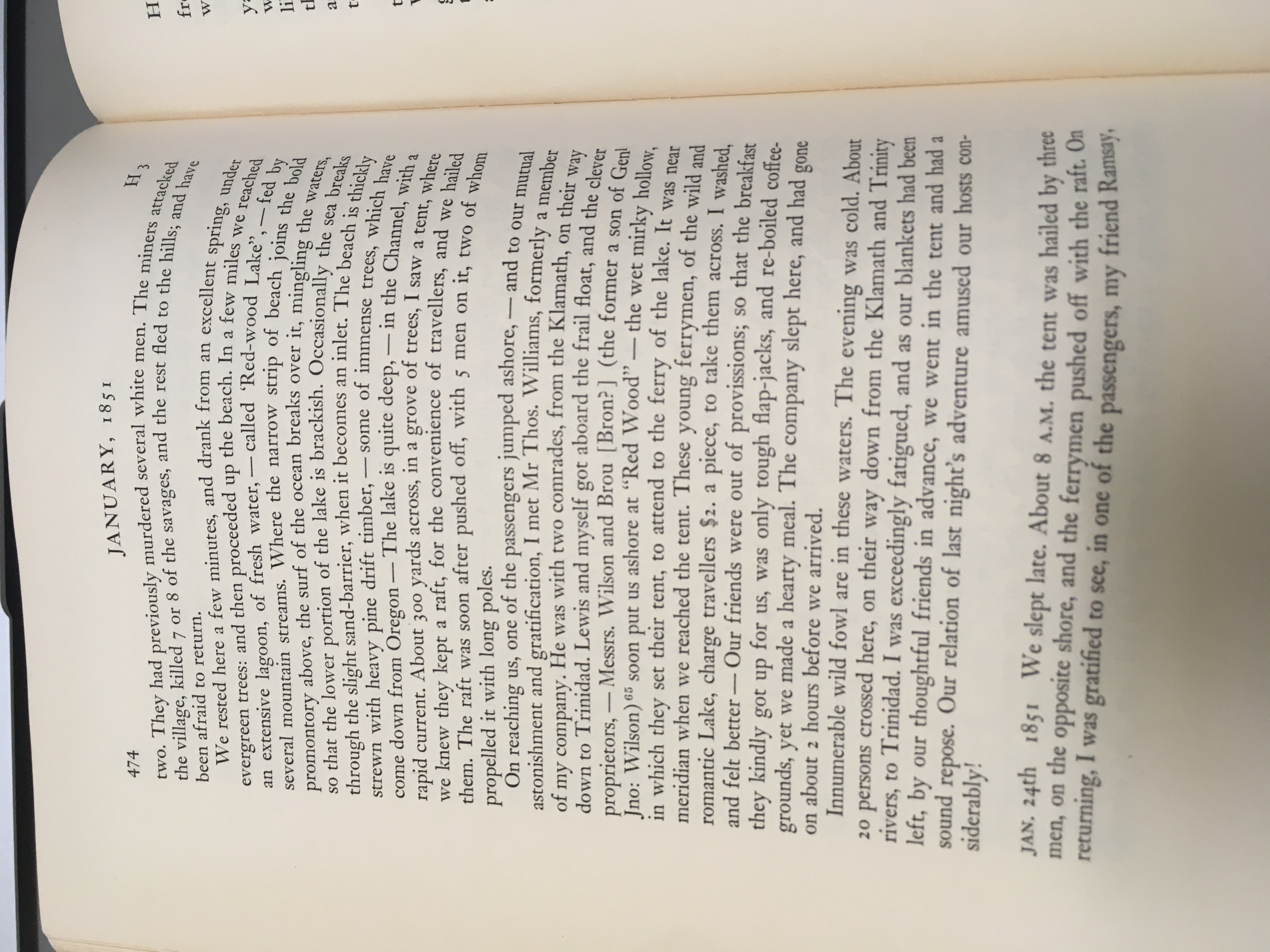
| III | Summer, 1850 | 7 – 8 | Osagen? North of Gold Bluffs | Bruff, Journals, 474. Tony Platt pointed out that this was north of Big Lagoon | http://nahc.ca.gov/webmaster/atlas/evidence/i0691a.jpg |
| III | Summer, 1850 | 14 | Burnt Ranch on Trinity River, “twenty-five kilometers down below Big Bar” | De Massey, “Frenchman in the Gold Rush [Part III],” 229-231 | http://nahc.ca.gov/webmaster/atlas/evidence/i0692a.pdf |
| III | Before August 13, 1850 | 50 – 60 | Junction of Klamath and Trinity Rivers | SYNTAX in DAC, August 20, 1850, 2 | http://nahc.ca.gov/webmaster/atlas/evidence/i0694.pdf |
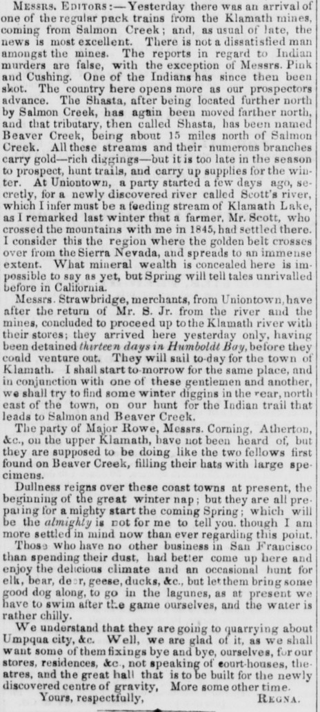
| II | October 1850 | 1 | Trinidad Region | REGNA in DAC, November 23 1850, 2 | http://nahc.ca.gov/webmaster/atlas/evidence/i0136a.jpg |
| III | Before November 11, 1850 | 15 – 20 | Eel River Valley | La Motte, “Statement of H.D. La Motte,” 11; DAC, November 11, 1850, 2 | http://nahc.ca.gov/webmaster/atlas/evidence/i0701.pdf
|
| II | Spring, 1851 | 2 – 3 | Several miles north of Trinidad | Wells, History of Siskiyou County, 127 | http://nahc.ca.gov/webmaster/atlas/evidence/i0154a.pdf |
| II | Spring, 1851 | 2 | In the vicinity of Blackburn’s Ferry on the Klamath River | Wells, History of Siskiyou County, 127 | http://nahc.ca.gov/webmaster/atlas/evidence/i0155a.pdf |
| II | May, 1851 | 4+ | Smith River Valley | T.J.R., May 26, 1851 in DAC, July 2, 1851, 2 | http://nahc.ca.gov/webmaster/atlas/evidence/i0163a.pdf |
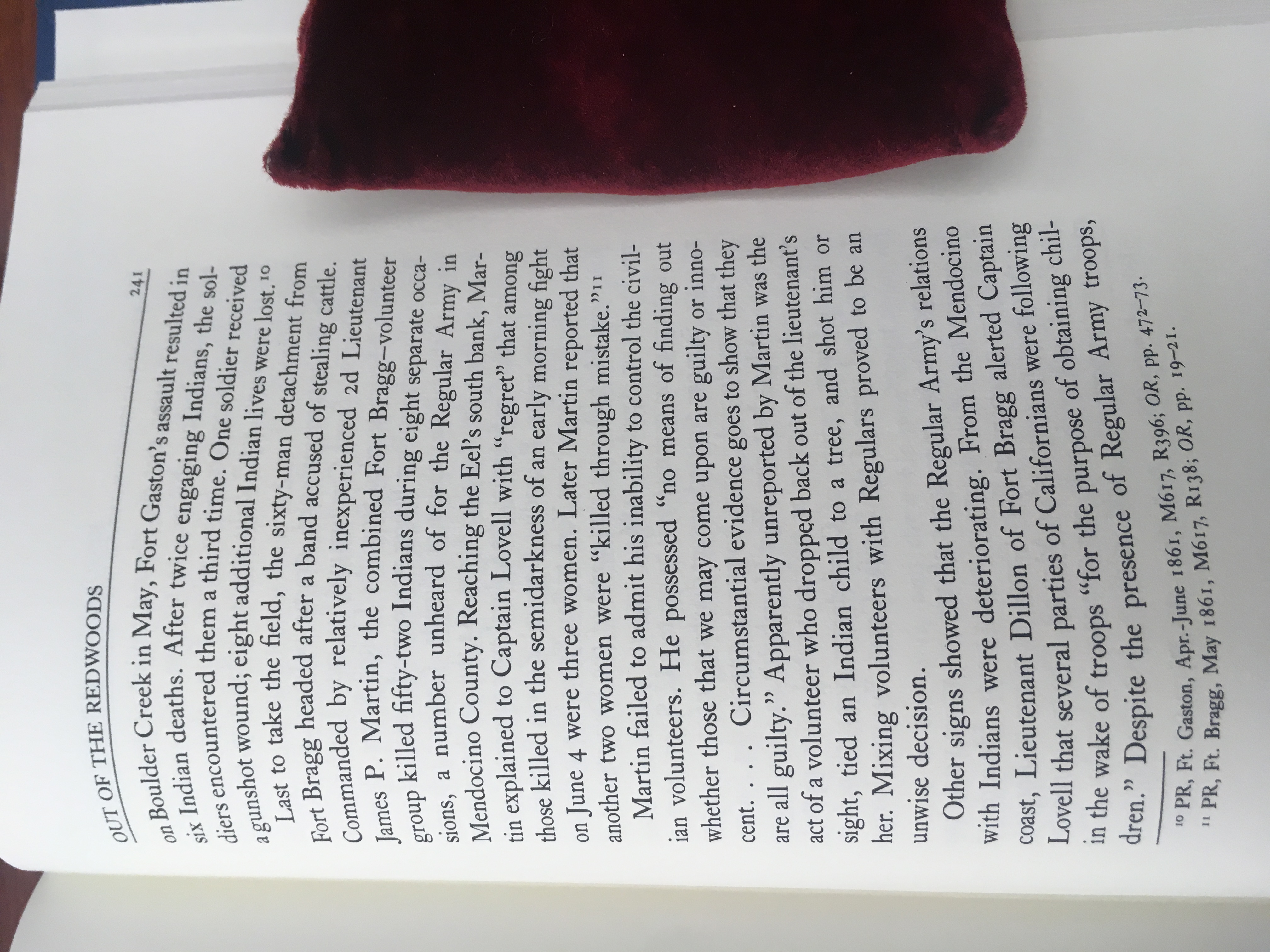
| II | Between May 28 and June 16, 1851 | 1, A “child” | South Fork of Eel River | Strobridge, Regulars in the Redwoods, 241 | http://nahc.ca.gov/webmaster/atlas/evidence/i1063a.jpg |
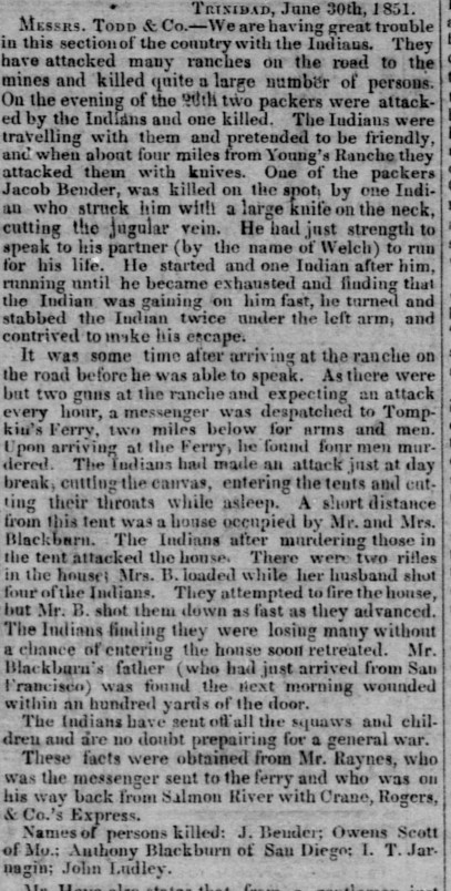
| II | June 26, 1851 | 4 | “Tompkin’s Ferry” near Young’s Ranch and Trindad(?) | Anonymous, June 30, 1851 in DAC, July 6, 1851, 2 | http://nahc.ca.gov/webmaster/atlas/evidence/i0166a.jpg |
| I | February 1852 | 3 | “near Eureka and the mouth of Elk river” | McKee to Bigler April 5, 1852, in California, Senate Journal, 1852, 712; also in NARA, RG75, M234, Roll 32:853 | http://nahc.ca.gov/webmaster/atlas/evidence/i0037a.pdf |
| II | February, 1852 | 3 – 4 | Eel River | McKee to Bigler April 5, 1852, in California, Senate Journal 1852, 712 | http://nahc.ca.gov/webmaster/atlas/evidence/i0178a.pdf |
| III | February, 1852 | 18 – 23 | Incidents at the mouth Eel River and up Eel River | McKee to Bigler April 5, 1852, in California, Senate Journal, 1852, 712. See also McKee to Bigler, April 5, 1852 in NARA, RG75, M234, 32:853 | http://nahc.ca.gov/webmaster/atlas/evidence/i0735a.pdf |
| II | Spring, 1852 | 1 | “On the trail near where Loleta now stands” | Loud, “Ethnogeography and Archaeology of the Wiyot Territory,” 323 | http://nahc.ca.gov/webmaster/atlas/evidence/i0183a.pdf |
| III | 1852 or 1853 | ~28 | The coast “near the southern boundary of Oregon,” likely Crescent City Harbor | Manypenny, Our Indian Wards, 154-155 | http://nahc.ca.gov/webmaster/atlas/evidence/i0733a.pdf |
| III | Late December 1852 or early January 1853 | 18 – 20 | Near Lyon’s Ranch | Correspondent to Marysville Herald in DAC, January 22, 1853, 2 | http://nahc.ca.gov/webmaster/atlas/evidence/i0752.pdf |
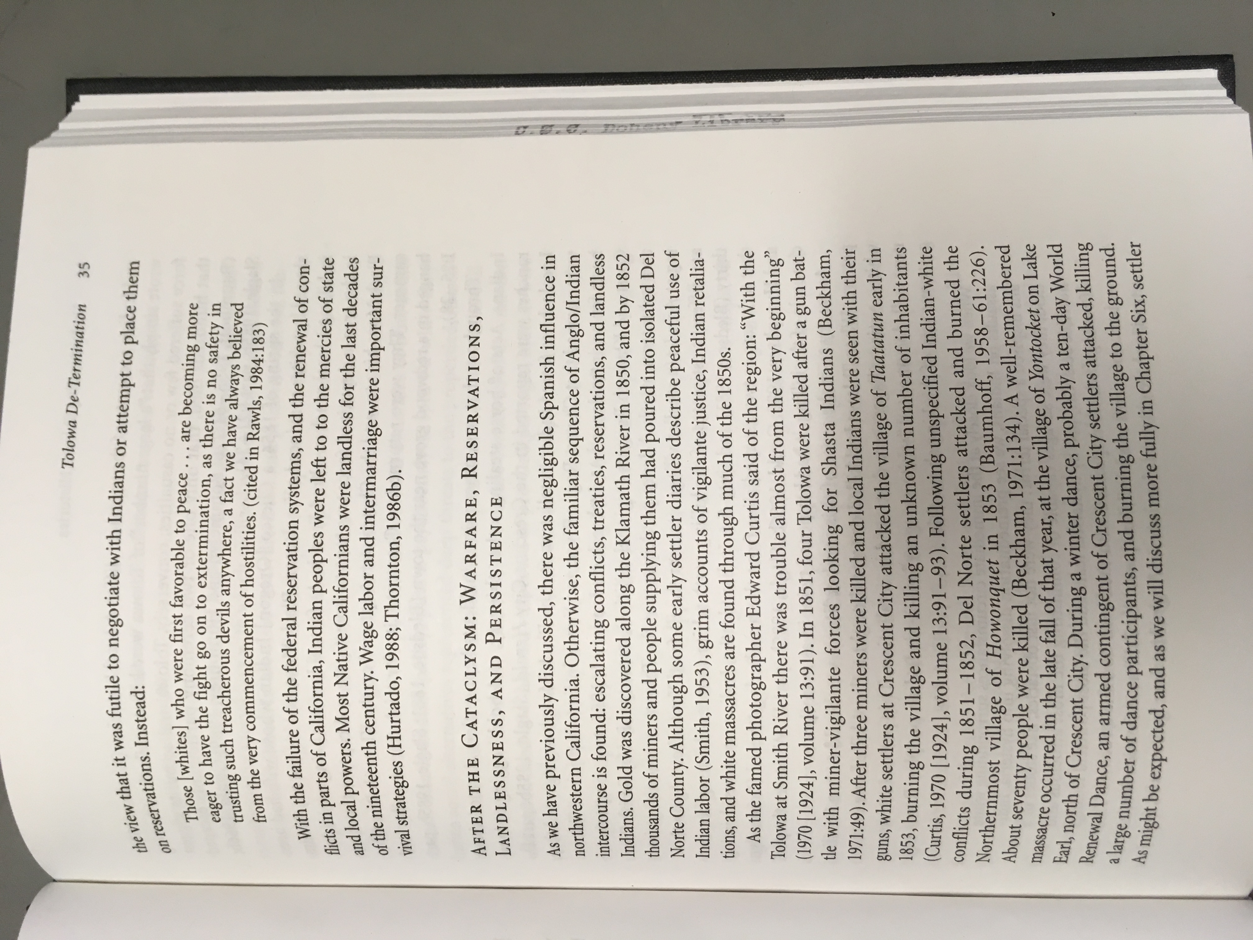
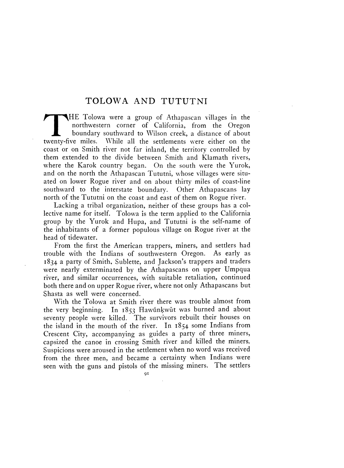
| I | Spring, 1853 | 4 | Taatatun (Battery Point, Crescent City) | Bledsoe, History of Del Norte County, 19; Collins, Understanding Tolowa Histories, 35 | http://nahc.ca.gov/webmaster/atlas/evidence/i0041a.pdf |
| III | Spring 1853 | 9 | Battery Point, Crescent City | Del Norte Record, June 26, 1880, 2; Collins, Understanding Tolowa Histories, 35 | http://nahc.ca.gov/webmaster/atlas/evidence/i1070b.jpg
|
| III | Late August or September, 1853 | 15 – 20 | Near Arcata | ABO, September 3, 1853 in Shasta Courier, September 10, 1853, 1 | |
| III | Fall, 1853 (?) | 70 | Howonquet, Near mouth of Smith River | Curtis, North American Indian, 13:91 | http://nahc.ca.gov/webmaster/atlas/evidence/i0768a.gif |
| III | October 24, 1853 | 8 – 15 | “Illinois Valley (the extreme south)” | Letter, April 25, 1852 in Shasta Courier in SDU, May 3, 1852, 3; Buck to Bradley, June 9, 1852, Franklin Augustus Buck Papers, Box 1, HL; Shasta Courier in SDU, May 3, 1852, 2 and Nevada Journal, May 8, 1852, 2; DAC, April 5, April 25, May 4, 1852, 2; Cox, Annals of Trinity County, 115; Stacer paraphrased in Golden Era, November 15, 1879, 3; Knapp, “Old Californian’s Pioneer Story, Part II,” 508; Brown (tawin thewis) summarized in McKibben summarized in Shriner, Thunder up the Creek, To-Mo-Kus Waket Awl-Wa-Mem, 237; McKibbin, Shepherd, ed., In My Own Words, 15 | http://nahc.ca.gov/webmaster/atlas/evidence/i0769b.pdf |
| III | Late Autumn, 1853 | 20 – 600 | Yontocket, 13 miles north of Crescent City | Peters in Coan, Del Norte Indian, 20; Del Norte Record, June 26, 1880, 2; Crook in Baldwin, “History of Smith River;” Lopez in Clausen and Spitzner, Del Norte Bites, 11; Thornton, Social Organization and the Demographic Survival of the Tolowa, 192; Bommelyn in Norton, When Our Worlds Cried, 54-56; Reed, “Neeyu Ne’ee min’ Nngheeyih,” 61 | http://nahc.ca.gov/webmaster/atlas/evidence/i0772e.pdf
http://nahc.ca.gov/webmaster/atlas/evidence/i0772f.pdf
|
| III | Early January, 1854 | 5 | “Burnt Ranch, Trinity River” | Shasta Courier, January 14, 1854, 2; SDU, January 18, 1854, 2 | |
| III | January 1854 | 7 | “about ten miles up” Smith River | Crescent City purser in DAC, January 19, 1854, 2 | http://nahc.ca.gov/webmaster/atlas/evidence/i0774.pdf |
| III | January 1854 | 8 | Near “the mouth of Smith’s River” | McCombe in DAC, January 19, 1854, 2 | http://nahc.ca.gov/webmaster/atlas/evidence/i0775.pdf |
| II | May, 1854 | 3 | “near the ferry on the Klamath” River | Yreka Herald in DAC, June 4, 1854, 2 | http://nahc.ca.gov/webmaster/atlas/evidence/i0273a.jpg |
| I | 1854 | 5 | “the Tátatténi at Crescent City” | Curtis, North American Indian, 13:91-92 | http://nahc.ca.gov/webmaster/atlas/evidence/i0042a.gif |
| II | July, 1854 | 1 | “near Trinidad” | Crescent City Herald in DAC, July 27, 1854, 2; SDU, July 28, 1854, 2 | http://nahc.ca.gov/webmaster/atlas/evidence/i0278a.jpg |
| II | July 13, 1854 | 3 | “South Fork of Trinity” | Adobe to Friend Courier, Shasta Courier, July 22, 1854, 2 | |
| II | November, 1854 | 2 | Crescent City | SDU, November 30, 1854, 3 | http://nahc.ca.gov/webmaster/atlas/evidence/i0285a.pdf |
| III | “latter part of 1854” | 12 | Village at mouth of Hayfork Creek and a second unidentified location between the mouth of Hayfork Creek and Burnt Ranch. | Cox, Annals of Trinity, 84-86 | http://nahc.ca.gov/webmaster/atlas/evidence/i0786a.pdf |
| II | December 10, 1854 | 1 | Unreported | HT, January 27, 1855, 2 | |
| III | December 31, 1854 | 30 – 200+ | Etchulet, four miles north of Crescent City | Crescent City Herald, January 3, 1855, 2; Myers to Adjutant General, March 10, 1855 in Military Records, Bin 3413-5, Coast Rangers, CSA; Bledsoe, History of Del Norte County, 32; white informants in Warburton and Endert, Indian Lore of the North California Coast, 168; Tolowa informants in Thornton, Social Organization and the Demographic Survival of the Tolowa, 192; Tolowa informants in Collins, Understanding Tolowa Histories, 36 | http://nahc.ca.gov/webmaster/atlas/evidence/i0790c.jpg
|
| I | January, 1855 | 1 | Del Norte County | Chase, They Pushed Back the Forest, 44 | http://nahc.ca.gov/webmaster/atlas/evidence/i0050a.jpg |
| II | Late 1854 or early 1855 (?) | 4 | Trinity County, possibly near Hyampom | Cox, Annals of Trinity County, 129 | http://nahc.ca.gov/webmaster/atlas/evidence/i0288a.jpg |
| III | Winter of 1854-1855 | 11 – 12 | Area between South and Main forks of the Trinity | Cox, Annals of Trinity County, 86 | http://nahc.ca.gov/webmaster/atlas/evidence/i0788a.jpg |
| II | January 16, 1855 | 2 – 3 | “in the vicinity of Redwood” | HT, January 20, 1855, 2. This number is not part of the total presented at the end of this appendix as it is included in Appendix III. | |
| II | Before January 17, 1855 | 3 | Unreported | Crescent City Herald, January 17, 1855, 2 | |
| III | Before January 18, 1855 | 7+ | “at the mouth of Redwood creek, and others at the Lagoon” | Crescent City Herald, January 31, 1855, 2 | |
| III | Before January 19, 1855 | 5 | Smith River | SDU, January 19, 1855, 2 | http://nahc.ca.gov/webmaster/atlas/evidence/i0793.pdf |
| II | February 4, 1855 | 2 | Near “Cappel and Morro ranches” | HT, February 10, 1855, 2 | |
| III | February 5, 1855 | 20 | Morro/Moreo Ranch | HT, February 10, 1855, 2; HT, February 17, 1855, 2; Wool to Thomas, April 11, 1855, S. Exec. Doc. 1, Part 2, 34th Cong., 1st and 2nd sessions, 75 | http://nahc.ca.gov/webmaster/atlas/evidence/i0794c.pdf |
| III | February 5, 1855 | 6 | Cappel Ranch | HT, February 10, 1855, 2 and February 17, 1855, 2; Wool to Thomas, April 11, 1855, S. Exec. Doc. 1, Part 2, 34th Cong., 1st and 2nd sessions, 75 | http://nahc.ca.gov/webmaster/atlas/evidence/i0795c.pdf |
| I | Before March 19, 1855 | 10 “a large number” | Near Weitchpec? | Crescent City Herald, March 19, 1855, 2. | |
| II | On or about May 21, 1855 | 1 | Near “Camp Wool” | Nicht in HT, June 9, 1855, 2 | |
| III | July 11, 1855 (not clear if the 15 were on the same day) | 3 – 15 | “Weeott river” | HT, July 14, 1855, 2; SDU, August 1, 1855, 2 | |
| II | Before August 20, 1855 | 1 – 2 | “Mah-to Valley,” Mattole Valley | White to Henley, August 20, 1855, NARA, RG 75, M234, 34:685-686 | |
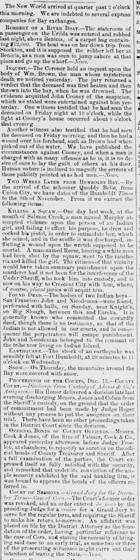
| II | Before November 8, 1855 | 2 | “near Knight’s, on Big Slough, between this and Eureka” | HT, November 8, 1855 in SDU, December 14, 1855, 2 | http://nahc.ca.gov/webmaster/atlas/evidence/i0317a.jpg |
| III | Before April 5, 1856 | 5+ | “towards the head of Yager Creek” | HT, April 5, 1856, 2 | |
| II | May 5, 1856 | 1 | Smith River region | Gilmore to Johnson, May 5, 1856, IWP F3753:284 | |
| II | May 10, 1856 | 1 | Smith River | Kibbe, “Annual Report of the Quarter-Master and Adjutant General,” 10-11 in California, Appendix to Assembly Journals for the Eighth Session of the Legislature of the State of California | http://nahc.ca.gov/webmaster/atlas/evidence/i0324a.pdf |
| II | On or After May 31, 1856 | 3 | Smith River | Kibbe, “Annual Report of the Quarter-Master and Adjutant General,” 10-11 in California, Appendix to Assembly Journals for the Eighth Session of the Legislature of the State of California | http://nahc.ca.gov/webmaster/atlas/evidence/i0327a.pdf |
| III | July, 1856 | 20 – 30 | Two villages on or near Smith River | Bradford, Biographical Sketches, 48-49 | http://nahc.ca.gov/webmaster/atlas/evidence/i0819a.pdf |
| III | August 1856 | 7 | “Pine Creek, twenty-seven miles from [Arcata].” | Bledsoe, Indian Wars, 207 | http://nahc.ca.gov/webmaster/atlas/evidence/i0820a.pdf |
| III | September 30, 1856 | 3 – 15 | Near Bald Mountain and Redwood Creek, east of Hempfield’s ranch | H.Y.L., October 2, 1856 in HT, October 4, 1856, 2; HT, October 4, 1856, 2, reprinted in SDU, October 14, 1856, 3; Bledsoe, Indian Wars, 208 | http://nahc.ca.gov/webmaster/atlas/evidence/i0826c.pdf |
| III | Before November 15, 1856 | 7 | Grizzly Bluff, “toward Bear River” | HT, November 15, 1856, 2, reprinted in DEB, November 29, 1856, 1 | |
| III | March 23, 1857 | 15 | “On the Hay Fork of Trinity River” | Shasta Republican, April 4, 1857, 2, summarized in SDU, April 8, 1857, 2, DAC, April 9, 1857, 2, and DEB, April 9, 1857, 3. Story retracted three weeks later in Shasta Republican, April 25, 1857, 4 | http://nahc.ca.gov/webmaster/atlas/evidence/i0833.pdf |
| II | 1858 | 4 | Hyampom, Trinity County | Cox, Annals of Trinity County, 129 | http://nahc.ca.gov/webmaster/atlas/evidence/i0373a.jpg |
| II | 1858 | 4 | Hiampum, Trinity County | Cox, Annals of Trinity County, 129 | http://nahc.ca.gov/webmaster/atlas/evidence/i0411a.jpg |
| II | February 13, 1858 | 0 – 2 | “about three miles from Angel’s Ranch” | Zentner in HT, February 13, 1858, 2; DAC, March 3, 1858, 1 | http://nahc.ca.gov/webmaster/atlas/evidence/i0377.pdf |
| II | May, 1858 | 4 | Eel River Region | Loud, “Ethnography and Archaeology of the Wiyot Territory,” 327 | http://nahc.ca.gov/webmaster/atlas/evidence/i0387a.pdf |
| II | Before May 29, 1858 | 1 | Eel River Region | Loud, “Ethnography and Archaeology of the Wiyot Territory,” 328 | http://nahc.ca.gov/webmaster/atlas/evidence/i0391a.pdf |
| II | May 29, 1858 | 2 | “Eel river, a few miles above the mouth” | HT, June 12, 1858, 2; DAC, June 16, 1858, 2; DEB, June 22, 1858, 1; SDU, June 24, 1858, 3 | http://nahc.ca.gov/webmaster/atlas/evidence/i0392.pdf |
| III | Early June 1858 | 15-20 | Mattole Valley | HT, June 19, 1858, 2 | |
| III | Before July 10, 1858 | 12 | Mad River | Trinity Journal, ND in HT, July 10, 1858, 2. The Humboldt Times denied that, “an attack had been made upon the Indians on Mad river when the [Trinity Journal] item was written” (HT, July 10, 1858, 2) | |
| III | July 15, 1858 | 10 – 257 (reportedly including “83 women, and 67 children”) | “on Grouse Creek” or “on Upper Grouse Creek” | HT, July 17, 1858, 2 in SDU, July 27, 1858, 2 and DAC, July 27, 1858, 1; Yreka Union, July 29, 1858 in DEB, August 4, 1858, 3; DAC, August 5, 1858, 1; Brown, “Indian Wars in Trinity, 1858-1865,” 37 | http://nahc.ca.gov/webmaster/atlas/evidence/i0854.pdf |
| III | Before July 21, 1858 | 15 | Redwood or Upper Mad River | F.E.W., July 20, 1858 in Crescent City Herald, July 28, 1858, 2 | |
| III | Summer of 1858 | 40 – 50 | Mattole Valley | Browne, September 29, 1858, NARA, RG75, M234, Reel 36:436 | |
| I | August 2, 1858 | 3 | “near the Three Creeks, about two miles from Lack’s trail, leading to… Hoopa Valley” | HT, August 7, 1858, 2; DAC, August 20, 1858, 1 | http://nahc.ca.gov/webmaster/atlas/evidence/i0057b.jpg |
| II | August 2, 1858 | 1 | HT, August 7, 1858, 2; DAC, August 19, 1858, 1 | http://nahc.ca.gov/webmaster/atlas/evidence/i0396.pdf | |
| II | Before August 7, 1858 | 1 | HT, August 7, 1858, 2; DAC, August 19, 1858, 1 | http://nahc.ca.gov/webmaster/atlas/evidence/i0397.pdf | |
| III | October 23 or 26, 1858 | 8 – 10 | Near Pardee’s Ranch (Near Maple Creek) “about eight miles above Mad River” according to Messic | HT, October 30, 1858, 2, reprinted in SDU, November 8, 1858, 4; Telegram dated Weaverville, November 1, 1858 in DAC, November 2, 1858, 1; Trinity Journal, November 6, 1858, 1, reprinted in Butte Record, November 13, 1858, 4; Shasta Courier, November 6, 1858, 2; Kibbe to Weller, April 7, 1859 in California, Senate Journal, 1859, 667; Brown, “Indian Wars in Trinity, 1858-1965,” 38 | http://nahc.ca.gov/webmaster/atlas/evidence/i0859.pdf
http://nahc.ca.gov/webmaster/atlas/evidence/i0859e.pdf
|
| III | October 25, 1858 | 8 | “Hoopa Valley Indians” located “20 miles from Humboldt” | Woodley or Woodly in DEB, November 9, 1858, 2 and DAC, November 10, 1858, 1. NOTE: This likely refers to the killing described below. | http://nahc.ca.gov/webmaster/atlas/evidence/i0858.pdf |
| III | November 13-14, 1858 | 5 – 6 | “near Showers’ Pass, in the Yager Creek country.” | HT, November 20, 1858, 2, reprinted in SDU, December 2, 1858, 2 and Butte Record, December 4, 1858, 1; Trinity Journal, November 20, 1858, 2, reprinted in Shasta Courier, November 27, 1858, 2; Brown, “Indian Wars in Trinity, 1858-1965,” 38 | http://nahc.ca.gov/webmaster/atlas/evidence/i0860c.jpg |
| II | Before December 4, 1858 | 2 | On or near “the Van Dusen” | HT, December 11, 1858, 2 | |
| II | Before December 4, 1858 | 4 | HT, December 11, 1858, 2 | ||
| II | December 16 or 17, 1858 | 1 | “near Mad river” | Jones in Northern Californian, December 22, 1858, 2 in DAC, January 6, 1858, 1 | http://nahc.ca.gov/webmaster/atlas/evidence/i0409.pdf |
| II | December 16 or 17, 1858 | 1 – 3 | Near Angel’s Ranch | Jones in Northern Californian, December 22, 1858, 2 in DAC, January 6, 1858, 1 | |
| III | October 1858 to April 4, 1859 | 75 – 100 | Summary of Second Klamath and Humboldt Expedition in Humboldt Region | HT, March 26, 1859, 2; Kibbe to Governor Weller, April 7, 1859 in California, Senate Journal, 1859, 667-670 | http://nahc.ca.gov/webmaster/atlas/evidence/i0879b.pdf |
| III | On or before January 21, 1859 | ~20 | “about seventeen miles east of Dow’s Prairie” | Kibbe in Northern Californian, extra, January 22, 1859 reprinted in Northern Californian, January 26, 1859, 2, SDU, January 27, 1859, 2, DAC, January 28, 1859, 1, and Shasta Courier, February 5, 1859, 3 | |
| II | January 21 or 22, 1859 | 1 | “on Redwood creek, near Albee’s rancho” | SDU, January 27, 1859, 2; Crescent City Herald, February 2, 1859, 3 | http://nahc.ca.gov/webmaster/atlas/evidence/i0414.pdf |
| I | January 28, 1859 | 3 | “Redwood” Creek | HT, February 5, 1859, 2; Brown, “Indians Wars of Trinity, 1858-1865,” 38 | http://nahc.ca.gov/webmaster/atlas/evidence/i0058b.jpg |
| III | January 28, 1859 | 15 | Near Dow’s Prairie | HT, January 29, 1859, 2 | |
| III | March 26, 1859 | ~100 | Summary of Second Klamath and Humboldt Expedition | HT, March 26, 1859, 2 | |
| II | May 10, 1859 | 2 – 3 | “in the vicinity of Yager Creek” | Hydesville informant in HT, May 14, 1859, 2 | |
| II | Between May 26 and May 31, 1859 | 2 | North Yager Creek | HT, June 4, 1859, 2 | |
| III | June 1, 1859 | 7 | Near Yager Creek | Hardcastle, June 3, 1859 journal entry | http://nahc.ca.gov/webmaster/atlas/evidence/i0882a.pdf |
| II | On or before June 5, 1859 | 0 – 3 | On Van Duzen River | Hardcastle, June 5, 1859 journal entry, “[Journal of a] March” | http://nahc.ca.gov/webmaster/atlas/evidence/i0424a.pdf |
| III | On or before June 5, 1859 | 5 | “redwoods near Yager” Creek, nor far from Fort Humboldt | Hardcastle, June 5, 1859 journal entry | http://nahc.ca.gov/webmaster/atlas/evidence/i0883a.pdf |
| I | Before June 11, 1859 | 10 “quite a number” | Possibly Yager Creek area | HT, June 11, 1859, 2 | |
| II | Late June or early July, 1859 | 1 | in the vicinity of “Kush-Kish, about 12 miles below Mattole” | HT, July 9, 1859, 2, reprinted in DEB, July 11, 1859, 3 | |
| II | July, 1859 | 1 | Klamath County | Northern Californian in DAC, July 13, 1859, 1 and SDU, July 14, 1859, 2 | http://nahc.ca.gov/webmaster/atlas/evidence/i0429.pdf |
| II | Before July 7, 1859 | 1 | “Kush-Kish, about twelve miles below Mattole” | HT, July 7, 1859 in SDU, July 13, 1859, 4 | http://nahc.ca.gov/webmaster/atlas/evidence/i0430.pdf |
| III | Between September 7 and 10, 1859 | 7 | “on Van Duzen Fork, east of the Redwood” | HT, September 17, 1859, 2, reprinted in DAC, September 25, 1859, 1 | http://nahc.ca.gov/webmaster/atlas/evidence/i0896.pdf |
| III | Last week of September, 1859 | 25 | “near the forks of Eel river” | A Stock Raiser, October 1, 1859, in Sonoma County Journal, October 7, 1859, 2; Petaluma Journal, October 1, 1859 in DAC, October 9, 1859, 1 | |
| III | October 12, 1859 | 20 | About 25 miles north of Round Valley | Jarboe in Santa Rosa Democrat in DEB, November 7, 1859, 2 | |
| III | November 18, 1859 | 7 | “Eel River country” | Jarboe to Goodrich, November 28, 1859 in DEB, January 4, 1860, supplement, 2 | |
| II | Before November 28, 1859 | 1 | Mattole Valley | Mat in HT, December 3, 1859, 2 | |
| III | December 9, 1859 | ~30 – 88 | On or near “South Eel river” | Santa Rosa Democrat, December 20, 1859 in DAC, January 1, 1860, 1; Observer, January 23, 1860 in SDU, February 1, 1860, 4 | http://nahc.ca.gov/webmaster/atlas/evidence/i0905.pdf |
| III | December 15 or 16, 1859 | 15 | Coast south of Mattole Valley | Mat., December 20, 1859 in HT, December 24, 1859, 2 | |
| III | December 31, 1859 | 60 | South Eel River | “A writer to the Santa Rosa Democrat,” summarized in Weekly Humboldt Times, January 21, 1860, 2 | |
| III | January, 1860 | 7 – 8 | “the house belonging to Isaac Minor on Redwood Creek” | Loud, “Ethnogeography and Archaeology of the Wiyot Territory,” 320 | http://nahc.ca.gov/webmaster/atlas/evidence/i0913a.pdf |
| II | Before January 18, 1860 | 3 | North fork of Yager Creek | Northern Californian in HT, January 21, 1860, 3 and SDU, January 26, 1860, 3 | http://nahc.ca.gov/webmaster/atlas/evidence/i0440.pdf |
| III | February, 1860 | 6 | Van Duzen River | Correspondent, June 1, 1860 in DEB, June 1, 1860, 2, reprinted in SDU, June 4, 1860, 4 | http://nahc.ca.gov/webmaster/atlas/evidence/i0921.pdf |
| III | February 1860 | 40 | “South fork of Eel River” | Rains to Hendricks, April 30, 1860, NARA, RG75, M234, Reel 37:1162 | http://nahc.ca.gov/webmaster/atlas/evidence/i0683.pdf |
| III | February 26, 1860 | 80 – 250+ | The three Humboldt Bay Massacres at Tuluwat or Indian Island, South Beach, and Eel River | Rossiter, February 26, 1860 in DEB, March 2, 1860, 3; Lord in DEB, February 28, 1860, 2; Van Ness in DEB, February 28, 1860, 2; telegram, February 28, 1860 in SDU, February 29, 1860, 2; Van Ness, February 29, 1860 in DEB, March 2, 1860, 3; Hutchings’ California Magazine, April 1860, 477; Northern Californian, February 29, 1860 in SDU, March 15, 1860, 2; Rains to Hendricks, April 30, 1860, NARA, M234, Reel 37:1163-1164; Gunther in Genzoli and Martin, Redwood Cavalcade, 12 | |
| III | February 29, 1860 | 26 – 35 | At or “above Eagle Prairie on Eel River” | HT, March 3, 1860, 2, reprinted in SDU, March 15, 1860, 2; “Eye-Witness” in DEB, March 13, 1860, 3; Raines to Hendricks, April 30, 1860, NARA, M234, 37:1164; Glaucus, March 16, 1860 in New York Times, April 12, 1860, 8 | |
| I | March 1, 1860 | 1 | “another ranch opposite ‘the Slide’” not far from Eagle Prairie | HT, March 3, 1860, 2; SDU, March 15, 1860, 2 | http://nahc.ca.gov/webmaster/atlas/evidence/i0064b.jpg |
| I | Before March 30, 1860 | 3 | South Eel River | ANTI-THUG to Bulletin, March 31, 1860 in Daily Evening Union, April 11, 1860, 3, reprinted in SDU, April 13, 1860, 2 | http://nahc.ca.gov/webmaster/atlas/evidence/i0065a.jpg |
| II | Before March 30, 1860 | 2 | Eel River | ANTI-THUG, March 31, 1860 in Daily Evening Union, April 11, 1860, 3, reprinted in SDU, April 13, 1860, 2 | http://nahc.ca.gov/webmaster/atlas/evidence/i0443.pdf |
| II | April, 1860 | 1 | Van Duzen River | Correspondent, June 1, 1860 in DEB, June 1, 1860, 2, in SDU, June 4, 1860, 4 | http://nahc.ca.gov/webmaster/atlas/evidence/i0444.pdf |
| II | April 10, 1860 | 1 | Shelter Cove | Rollins in HT, April 28, 1860, 3 | |
| III | Before April 14, 1860 | 6 | Shelter Cove, Southern Humboldt Coast | Carlin to Ford, April 14, 1860; Carlin to Mackall, April 25, 1860; Carlin to Hamilton and Oliver, April 25, 1860 in Strobridge, Regulars in the Redwoods, 199-200 | http://nahc.ca.gov/webmaster/atlas/evidence/i0924a.pdf
http://nahc.ca.gov/webmaster/atlas/evidence/i0924b.pdf
|
| II | April 26, 1860 | 1 | L—’s ranch on the Van Duzen River in Wiyot Territory | Correspondent, June 1, 1860 in DEB, June 1, 1860, 2; Loud, “Ethnogeography and Archaeology of the Wiyot Territory,” 322 | http://nahc.ca.gov/webmaster/atlas/evidence/i0448b.pdf |
| II | Before May 9, 1860 | 2+ | “near Big Bend, Mad River” | Crescent City Herald, May 9, 1860 in DAC, May 12, 1860, 1 | http://nahc.ca.gov/webmaster/atlas/evidence/i0450.pdf |
| III | June 2, 1860 | 12 (including two women) | “a short distance above Big Bend, on Mad River” | Northern Californian, June 20, 1860 in HT, June 16, 1860, 2, DEB, June 23, 1860, 2 and SDU, June 25, 1860, 4 | |
| II | Before September 15, 1860 | 1 | Hoopa Valley | HT, September 15, 1860, 2; September 29, 1860, 2; DAC, October 10, 1860, 1; SDU, October 12, 1860, 2 | http://nahc.ca.gov/webmaster/atlas/evidence/i0463.pdf |
| II | September 27, 1860 | 2 | Eureka | DAC, October 10, 1860, 1 | http://nahc.ca.gov/webmaster/atlas/evidence/i0464.pdf |
| II | On or about December 1, 1860 | 3 | Armstrong’s “near the South Eel river settlement” | Swift in DAC, December 9, 1860, 1 and in HT, December 29, 1860, 3 | http://nahc.ca.gov/webmaster/atlas/evidence/i0468.pdf |
| III | On or about December 2, 1860 | 7+ | South Eel River | Swift in DAC, December 9, 1860, 1; HT, December 29, 1860, 3 | |
| III | On or just after December 5, 1860 | ~6 | Near “Van Dussen Fork” | Tracey in HT, December 8, 1860, 3, reprinted in DAC, December 14, 1860, 1 | http://nahc.ca.gov/webmaster/atlas/evidence/i0931.pdf |
| II | 1860 or 1861 | 1 | On the coast near Bucksport | Loud, “Ethnogeography and Archaeology of the Wiyot Territory,” 335 | http://nahc.ca.gov/webmaster/atlas/evidence/i0469a.pdf |
| II | 1860 or 1861 | 1 | Duluwat Island in Humboldt Bay | Loud, “Ethnogeography and Archaeology of the Wiyot Territory,” 335 | http://nahc.ca.gov/webmaster/atlas/evidence/i0470a.pdf |
| II | January 8, 1861 | 4 | Yager Creek Region | Humboldt Times, January 12, 1861 in DEB, January 17, 1861, 3 | |
| III | January 28, 1861 | 13+ | “Inqua Ranch, Middle Yager, Bald Hills” | HT, February 2, 1861, 3; reprinted in DEB, February 4, 1861, 3; telegram, February 4, 1861 in SDU, February 5, 1861, 2; Shasta Herald, February 16, 1861, 2 | http://nahc.ca.gov/webmaster/atlas/evidence/i0933.pdf |
| I | Before February 2, 1861 | 3 | South Fork Eel River | HT, February 2, 1861, 3 | |
| III | On or about February 2, 1861 | 39 | “on main Eel river, above the crossing of the old Sonoma trail” | HT, February 9, 1861, 3, reprinted in DAC, March 2, 1861, 1, DEB, March 2, 1861, 2 and SDU, March 4, 1861, 2 | http://nahc.ca.gov/webmaster/atlas/evidence/i0934.pdf |
| III | February 2, 1861 | 7 | Upper Mattole | HT, February 9, 1861, 3, reprinted in DAC, March 2, 1861, 1, DEB, March 2, 1861, 2, and SDU, March 4, 1861, 2 | http://nahc.ca.gov/webmaster/atlas/evidence/i0935.pdf |
| II | Before February 23, 1861 | 4 | “in the redwoods near North Yager Creek” | HT, February 23, 1861, 3, reprinted in DEB, March 2, 1861, 2, and DAC, March 2, 1861, 1 | |
| II | Before February 23, 1861 | 2 | Near Kentishou Valley, near Hydesville | Hydesville correspondent to HT, February 23, 1861, 2, reprinted in DEB, March 2, 1861, 2, and DAC, March 2, 1861, 1 | http://nahc.ca.gov/webmaster/atlas/evidence/i0474.pdf |
| I | Before March 9, 1861 | 3 | In or near Matole Valley | Goff in HT, March 9, 1861; DAC, March 20, 1861, 1 | http://nahc.ca.gov/webmaster/atlas/evidence/i0068b.jpg |
| III | March, April or May 1861 | 10 | “above Big Bend, Mad River” | Bledsoe, Indian Wars, 177-178 | http://nahc.ca.gov/webmaster/atlas/evidence/i0936a.pdf |
| III | Early April 1861 | 20 – 25 | Upper Mad River/ Van Duzen River | WOR, 1:50:1, 18 | http://nahc.ca.gov/webmaster/atlas/evidence/i0937a.pdf |
| III | April 14, 1861 | 15 – 20 | Near Mad River, about 20 miles from Neil’s Ranch | Collins to Lovell, April 15, 1861 in HT, April 20, 1861, 2 | |
| III | April 15, 1861 | 5+ | Near Mad River, about 20 miles from Neil’s Ranch | Collins to Lovell, April 15, 1861 in HT, April 20, 1861, 2 | |
| III | April 19, to May 9, 1861 | 15 | 2 incidents in Larabee creek region | WOR, 1:50:1, 12; HT, May 11, 1861, 2 reprinted in DAC, May 17, 1861, 1 | http://nahc.ca.gov/webmaster/atlas/evidence/i0940.pdf
|
| III | May 14, 1861 | 6 – 14+ | “on Boulder Creek, about seven miles from Blue Slide” on Mad River | HT, May 18, 1861, 3 reprinted in SDU, May 29, 1861, 2; Strobridge, Regulars in the Redwoods, 241 | http://nahc.ca.gov/webmaster/atlas/evidence/i0941.pdf
|
| III | May 1861 | 8 – 18 | Larrabee Creek (Main Eel River) | HT, May 18, 1861, 3; WOR, 1:50:1, 18 | http://nahc.ca.gov/webmaster/atlas/evidence/i0942b.pdf |
| II | Before May 20, 1861 | 1 | Eel River | May 20, 1861 telegram in SDU, May 21, 1861, 2 | http://nahc.ca.gov/webmaster/atlas/evidence/i0477.pdf |
| III | May 23, 1861 | 10 | “between the head of Larabee’s Creek and Main Eel River” | WOR, 1:50:1, 18-19 | http://nahc.ca.gov/webmaster/atlas/evidence/i0943a.pdf |
| III | Before May 25, 1861 | 15 | South Fork Eel River | HT, May 25, 1861, 2, reprinted in DEB, May 29, 1861, 2 | |
| II | May 26, 1861 | 4 | Larabee Creek region | WOR 1:50:1, 18-19 | http://nahc.ca.gov/webmaster/atlas/evidence/i0478a.pdf |
| III | May 28, 1861 | 8 | A South Fork Eel River village “about one mile above its mouth” | WOR, 1:50:1, 19-21 | http://nahc.ca.gov/webmaster/atlas/evidence/i0945a.pdf |
| III | May 30, 1861 | 25+ | Keatuck (or Kentuck) Creek; Main Eel River | Correspondent in HT, June 15, 1861, 3 reprinted in SDU, June 22, 1861, 2 and DEB, June 19, 1861, 3; Starer in HT, June 8, 1861, 2; WOR, 1:50:1, 18-19; San Francisco Herald, June 20, 1861, 2 | http://nahc.ca.gov/webmaster/atlas/evidence/i0946c.pdf |
| III | Between May 14, and June 1, 1861 | 5 – 8 | Redwood creek and Mad River area | HT, June 1, 1861, 2; Strobridge, Regulars in the Redwoods, 241 | http://nahc.ca.gov/webmaster/atlas/evidence/i0947b.jpg |
| III | June 2, 1861 | 20-23 | “Larrabee Creek” region | Collins to Lovell, June 18, 1861, WOR, 1:50:1, 19; Correspondent in HT, June 15, 1861, 3 reprinted in DEB, June 19, 1861, 3, San Francisco Herald, June 20, 1861, 2 and SDU, June 22, 1861, 2 | http://nahc.ca.gov/webmaster/atlas/evidence/i0948a.pdf |
| I | Before June 4, 1861 | 3 | Pilot Creek near Hyapom Valley | Donnelly in SDU, June 12, 1861, 1; Trinity Journal in Marysville Appeal, June 12, 1861, 2 | http://nahc.ca.gov/webmaster/atlas/evidence/i0069a.jpg |
| III | June 8, 1861 | 4 – 7 | “Larrabee Creek” region | 7: Correspondent to HT, June 15, 1861, 3 reprinted in SDU, June 22, 1861, 2 and DEB, June 19, 1861, 3; WOR, 1:50:1, 19 | http://nahc.ca.gov/webmaster/atlas/evidence/i0950.pdf
http://nahc.ca.gov/webmaster/atlas/evidence/i0950b.pdf
|
| III | June 14, 1861 | 7 | Above the mouth of the south fork of Eel River | WOR, 1:50:1, 19-21 | http://nahc.ca.gov/webmaster/atlas/evidence/i0951a.pdf |
| II | June 15 or 16, 1861 | 1 | Grouse Creek, near Arcata | Trinity Journal in SDU, July 2, 1861, 1 | http://nahc.ca.gov/webmaster/atlas/evidence/i0479.pdf |
| II | June 16, 1861 | 4 | Near Kettenshaw valley | WOR, 1:50:1, 19. | http://nahc.ca.gov/webmaster/atlas/evidence/i0481a.pdf |
| II | June 16, 1861 | 1 | Near Grouse Creek | Trinity Journal in Marysville Appeal, July 3, 1861, 3 | |
| III | June 16, 1861 | 5 | Near Kettenshaw valley | WOR, 1:50:1, 19-21 | http://nahc.ca.gov/webmaster/atlas/evidence/i0952a.pdf |
| III | June 16, 1861 | nine to ten | South Fork Eel River Region | WOR, 1:50:1, 19-21 | http://nahc.ca.gov/webmaster/atlas/evidence/i0953a.pdf |
| II | June 18, 1861 | 2 – 4 | Shelter Cove | San Francisco Herald, June 20, 1861, 2; Letter, June 27, 1861 in Marysville Appeal, July 9, 1861, 1 | http://nahc.ca.gov/webmaster/atlas/evidence/i0483.pdf |
| II | June 18, 1861 | 1 | Near Kettenshaw Valley | Collins to Lovell, June 18, 1861, and Martin to Lovell, June 27, 1861, WOR 1:50:1, 20. | http://nahc.ca.gov/webmaster/atlas/evidence/i1064a.pdf |
| II | June 19, 1861 | 1 | Elk River | HT, June 22, 1861, 3 | |
| I | On or after July 2, 1861 | 5 | Shelter Cove, southern Humboldt | Biaggi, “Shelter Cove Scalping,” 7-8 | http://nahc.ca.gov/webmaster/atlas/evidence/i0070a.pdf |
| III | June 17, 1861 | 6 | “a rancheria on the trail leading from Kettenshaw to Round Valley” | WOR, 1:50:1, 18-19 | http://nahc.ca.gov/webmaster/atlas/evidence/i0954a.pdf |
| II | Before July 20, 1861 | 2 – 3 | Long Prairie | HT, July 20, 1861, 2 | |
| III | June 21, 1861 | 8 | Mad River | HT, June 29, 1861, 2 | |
| III | July 21, 1861 | 12 | 25 miles up the south fork of the Eel river | WOR, 1:50:1, 21 | http://nahc.ca.gov/webmaster/atlas/evidence/i0957a.pdf |
| III | April 19 to June 22, 1861 | 117 | Summary of Collins’ Larabee Creek region campaign | HT, June 22, 1861, 2 | |
| II | Late July or Early August, 1861 | 3 | Shelter Cove Area | HT, July 27, 1861, 2; August 10, 1861, 3 | |
| II | September, 1861 | 2 – 3 | “Spruce Grove mail station—about forty-five miles from Hydesville” | HT, September 28, 1861, 2 | |
| I | October, 1861, or earlier | 3 | Eel River Region, Humboldt County | USOIA, Report of the Commissioner of Indian Affairs, 1862, 315 | http://nahc.ca.gov/webmaster/atlas/evidence/i0071a.jpg |
| II | October 10, 1861 | 2 | Larabee Creek | HT, October 19, 1861, 3 | |
| II | October 20, 1861 | 2 | Between Bear River Ridge and Eel River | HT, October 26, 1861, 2 | |
| III | November 17, 1861 | ~20 | Humboldt Region | Humboldt Times Extra, November 18, 1861 in SDU, November 30, 1861, 2; HT, November 23, 1861, 3 | |
| III | Between November 17 and November 23, 1861 | 15 | Humboldt Region | HT, November 23, 1861, 3; HT, November 30, 1861, 2; Tassin, “Con-cow Indians,” 10-11; Hanson to Dole, July 15, 1861, USOIA, Report of the Commissioner, 1861, 150; Potter, “Reminiscences of the early history of northern California and the Indian troubles,” 2 | http://nahc.ca.gov/webmaster/atlas/evidence/i0964c.pdf
http://nahc.ca.gov/webmaster/atlas/evidence/i0964d.jpg
http://nahc.ca.gov/webmaster/atlas/evidence/i0964e.jpg
|
| III | From September 9 to December 9, 1861 | 77– 79+ (including women) | Summary of Humboldt Home Guard expedition in Humboldt Region | Bledsoe, Indian Wars, 200; Werk in HT, December 21, 1861, 2 | |
| III | November 9, 1861 | 34 | Summary of Humboldt Home Guard Expedition | Werk in HT, November 9, 1861, 2 | |
| II | December 6, 1861 | 1 | “on the Upper North fork of the Mattole” | HT, December 2, 1861, 2 | |
| I | 1862? | 3 | Alderpoint Region, Humboldt County | Young in Murphey and Young, “Out of the Past,” 358 | http://nahc.ca.gov/webmaster/atlas/evidence/i0072a.pdf |
| III | February 9, 1862 | 5 | Near Big Bend, Mad River | HT, February 15, 1862, 3, reprinted in DEB, February 27, 1862, 3; HT, February 22, 1862 in SDU, March 3, 1862, 8 | http://nahc.ca.gov/webmaster/atlas/evidence/i0967.pdf |
| III | Before April 3, 1862 | 17 | Eel River/ Fort Seward | WOR, 1:50:1, 982 | http://nahc.ca.gov/webmaster/atlas/evidence/i0970a.pdf |
| II | April 5, 1862 | 2 | 1 mile from Fort Anderson | Correspondent, in HT, April 12, 1862, 3; SDU, April 16, 1862, 3 | http://nahc.ca.gov/webmaster/atlas/evidence/i0504.pdf |
| II | April 6, 1862 | 1 | Near Fort Anderson | Correspondent in HT, April 12, 1862, 2; WOR, 1:50:1, 53 | http://nahc.ca.gov/webmaster/atlas/evidence/i0505b.pdf |
| II | April 7, 1862 | 2 | Yager Creek | WOR 1:50:1, 86 | http://nahc.ca.gov/webmaster/atlas/evidence/i0506a.pdf |
| I | After April 9, 1862 | 10 | Blue Lake | Nora in Nomland, “Bear River Ethnography,” 105 | http://nahc.ca.gov/webmaster/atlas/evidence/i0073a.pdf |
| II | Before April 10, 1862 | 2 | Near Cooper’s Mill | SDU, April 16, 1862, 3 | http://nahc.ca.gov/webmaster/atlas/evidence/i0507.pdf |
| II | Before April 10, 1862 | 2 | Humboldt Bay Region | HT, April 12, 1862, 2 | |
| II | Before April 19, 1862 | 1 | Humboldt Bay Region? | HT, April 19, 1862, 2; DEB, April 22 1862, 2; SDU, April 24, 1862, 2 | http://nahc.ca.gov/webmaster/atlas/evidence/i0509.pdf |
| II | April 26, 1862 | 3 – 4 | Larabee Creek | WOR, 1:50:1, 55; SDU, May 10, 1862, 2 | http://nahc.ca.gov/webmaster/atlas/evidence/i0510a.pdf |
| III | April 26, 1862 | 5 | “near Eel river” | WOR 1:50:1, 79 | http://nahc.ca.gov/webmaster/atlas/evidence/i0972a.pdf |
| III | April 26, 1862 | 15 – 16 | South of Fort Baker | WOR, 1:50:1, 55; SDU, May 10, 1862, 2; Gelrick, May 4, 1862 in SDU, May 5, 1862, 4 | http://nahc.ca.gov/webmaster/atlas/evidence/i0974.pdf
|
| III | May 14, 1862 | 6 | Angel’s Ranch (Ridge above Korbel) | WOR, 1:50:1, 56 | http://nahc.ca.gov/webmaster/atlas/evidence/i0976a.pdf |
| II | Before May 15, 1862 | 1 | Near Fort Baker | WOR 1:50:1, 56. This killing is not included in the total at the bottom of this table because it is included in a summary in Appendix III. | http://nahc.ca.gov/webmaster/atlas/evidence/i0511a.pdf |
| II | May 31, 1862 | 1 | Humboldt Military District | WOR 1:50:1, 59. This killing is not included in the total at the bottom of this table because it is included in a summary in Appendix III. | http://nahc.ca.gov/webmaster/atlas/evidence/i0512a.pdf |
| II | Late May or Early June, 1862 | 1 | Eel River Region | WOR 1:50:1, 59. This killing is not included in the total at the bottom of this table because it is included in a summary in Appendix III. | |
| II | Between June 8 and June 10, 1862 | 2 – 3 | Daby’s Ferry | M., June 10, 1862 in SDU, June 14, 1862, 1 | http://nahc.ca.gov/webmaster/atlas/evidence/i0514.pdf |
| II | Before June 20, 1862 | 2 | Mattole Valley | WOR 1:50:1, 73 | http://nahc.ca.gov/webmaster/atlas/evidence/i0515a.pdf |
| III | June 7, 1862 | 6 | Mattole Valley | WOR, 1:50:1, 59 | http://nahc.ca.gov/webmaster/atlas/evidence/i0977a.pdf |
| II | July 9, 1862 | 1 | “near the Upper Crossing of Mad River” | WOR, 1:50:1, 82-83 | http://nahc.ca.gov/webmaster/atlas/evidence/i0519a.pdf |
| II | July 28, 1862 | 2 | Near Redwood Creek | HT, August 2, 1862, 2; SDU, August 6, 1862, 3; telegram, August 6, 1862 in SDU, August 7, 1862, 2 | http://nahc.ca.gov/webmaster/atlas/evidence/i0523.pdf |
| III | August 21, 1862 | 6 | Light’s Prairie (5 miles from Arcata) | HT, August 23, 1862 in DEB, August 30, 1862, 3; Correspondent, August 31, 1862 in SDU, September 18, 1862, 1; WOR, 1:50:1, 76-77 | http://nahc.ca.gov/webmaster/atlas/evidence/i0983c.pdf |
| III | August 24, 1862 | 22 – 40 (including 1 to 6 women) | Little River | HT, August 23, 1862 in DEB, August 30, 1862, 3; HT, August 30, 1862, 2; Correspondent, August 31, 1862 in SDU, September 18, 1862, 1; Bledsoe, Indian Wars, 396-398 | http://nahc.ca.gov/webmaster/atlas/evidence/i0984d.pdf |
| II | October 21, 1862 | 1 | Near Hydesville | WOR, 1:50:1, 179 | http://nahc.ca.gov/webmaster/atlas/evidence/i0528a.pdf |
| II | January 10, 1863 | 2 | “on the Iaqua Ranch” | HT, January 17, 1863, 2 | |
| III | Before January 24, 1863 | 6 – ~40 | At or near Fort Seward | Mendocino Herald in HT, January 24, 1863, 2; Letter summarized in HT, January 24, 1863, 2; Young in Murphey and Young, “Out of the Past,” 354 | http://nahc.ca.gov/webmaster/atlas/evidence/i0987c.pdf |
| III | Before February 17, 1863 | 23 | Near Fort Seward | Gear in HT, March 7, 1863, 2, reprinted in SDU, March 16, 1863, 3 | http://nahc.ca.gov/webmaster/atlas/evidence/i0988.pdf |
| III | Before March 22, 1863 | 12+ | North Fork of Eel River near Kitten Valley | WOR, 1:50:1, 194 | http://nahc.ca.gov/webmaster/atlas/evidence/i0991a.pdf |
| III | ~March 23, 1863 | 9 | North Fork of Eel River | WOR, 1:50:1, 195 | http://nahc.ca.gov/webmaster/atlas/evidence/i0992a.pdf |
| II | Before April 1, 1863 | 1 | Near “North Fork of Eel River” | WOR 1:50:1, 194 | http://nahc.ca.gov/webmaster/atlas/evidence/i0534a.pdf |
| III | Before April 11, 1863 | 30 – 38 | Near Big Bend, North Fork Eel River | HT, April 11, 1862, 2, reprinted in SDU, April 15, 1863, 3; Bledsoe, Indian Wars, 409 | http://nahc.ca.gov/webmaster/atlas/evidence/i0997.pdf
http://nahc.ca.gov/webmaster/atlas/evidence/i0997b.pdf
|
| II | May 9, 1863 | 4 | Near Shelter Cove | WOR, 1:50:1, 189, 196 | http://nahc.ca.gov/webmaster/atlas/evidence/i0536a.pdf |
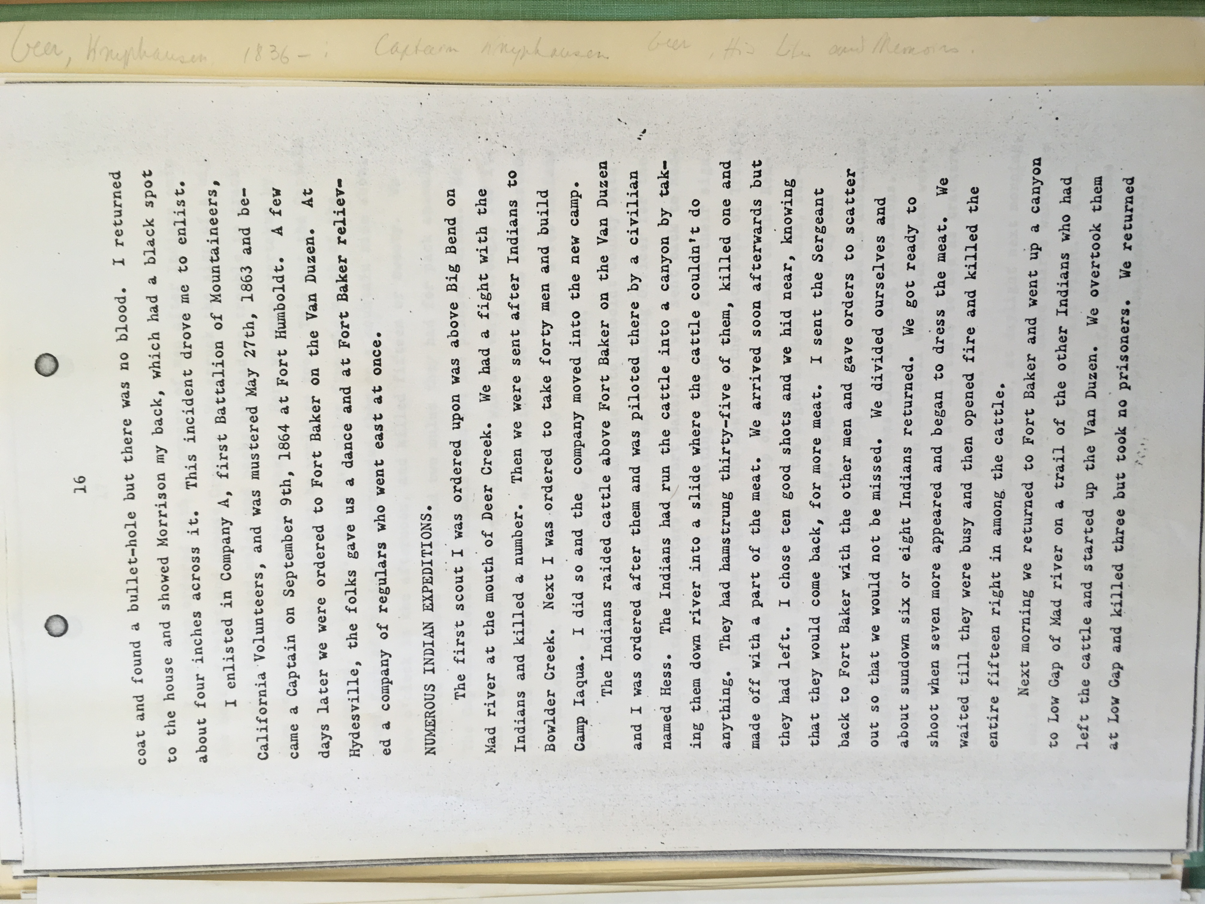
| I | June, 1863? | 3 | “above Big Bend, Mad River” | Geer, “Captain Knyphausen Geer,” 16 | http://nahc.ca.gov/webmaster/atlas/evidence/i0076a.jpg |
| II | After June 1863 massacre of 15 above Fort Baker | 3 | “Low Gap” in the Van Duzen basin | Geer, “Captain Knyphausen Geer,” 16 | http://nahc.ca.gov/webmaster/atlas/evidence/i0542a.jpg |
| II | June 16, 1863 | 1 | “Hiamboon, Trinity county” | Telegram, June 19, 1863 in SDU, June 20, 1863, 2 | http://nahc.ca.gov/webmaster/atlas/evidence/i0544.pdf |
| III | July 8, 1863 | 6 | On Redwood Creek in Humboldt County | HT, July 11, 1863, 2; HT, July 18, 1863, 2; Letter, July 25, 1863 in Beith, “Beith Letterbook,” 201 | http://nahc.ca.gov/webmaster/atlas/evidence/i1003c.pdf |
| II | Before July 11, 1863 | 3 | Humboldt Military District | HT, July 11, 1863, 3 | |
| II | Before July 11, 1863 | 1 | Humboldt Military District | HT, July 11, 1863, 3 | |
| III | July 23, 1863 | 6 | On Grouse Creek | HT, August 1, 1863, 3 | |
| II | Before July 3, 1863 | 4 | Humboldt Military District | HT, July 4, 1863, 3 | |
| II | Before September 4, 1863 | 1 | Fort Gaston | Neely in HT, September 12, 1863, 2; SDU, September 26, 1863, 4 | |
| III | Before September 12, 1863 | 10 | “North Eel river” | Eberle, September 12, 1863 in Mendocino Herald, September 18, 1863, 3 reprinted in Marysville Appeal, September 26, 1863, 3 | http://nahc.ca.gov/webmaster/atlas/evidence/i1008.pdf |
| II | Before September 19, 1863 | 1 | Humboldt Military District | WOR 1:50:1, 238 | http://nahc.ca.gov/webmaster/atlas/evidence/i0559a.pdf |
| II | Before October 30, 1863 | 1 | Smith River Reservation | WOR, 1:50:2, 661 | http://nahc.ca.gov/webmaster/atlas/evidence/i0563a.pdf |
| II | December 25, 26, 27, 1863 | 2+ | Christmas Prairie between Arcata and Trinity River. Near Bald Mountain on Redwood Creek, 5 miles east of Angel’s Ranch | HT, January 2, 1864, 3. Note: this may have been a mass killing of larger proportions. | |
| II | January 26, 1864 | 3 | “near Jonathon Lyon’s farm,” Humboldt Military District | HT, February 6, 1864, 2 | |
| III | February 2, 1864 | 13 – 14 | White Thorn Valley Rancherias, Upper Mattole | HT, February 20, 1864, 3; Orton, California Men, 830; Bledsoe, Indian Wars, 254 | http://nahc.ca.gov/webmaster/atlas/evidence/i1010b.pdf
|
| II | February 29, 1864 | 3 | “ridge between Mad river and Redwood Creek, not far from the point known as Snyder’s ranch” | WOR 1:50:1, 287; HT, March 12, 1864, 2 in Bancroft Scraps, 36:126 | http://nahc.ca.gov/webmaster/atlas/evidence/i0573a.pdf
|
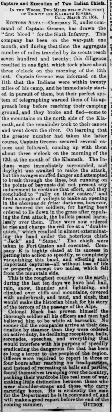
| I | March 12, 1864 | 8 | “at the mouth of the Klamath” | Guidon, March 29, 1864 in DAC, April 19, 1864, 1 | http://nahc.ca.gov/webmaster/atlas/evidence/i0079a.jpg |
| II | After March 17, 1864 | 2 | Fort Gaston | Call in Weekly Trinity Journal, April 16, 1864, 2; Guidon in DAC, August 28, 1864(?) in Bancroft Scraps, 36:128 | http://nahc.ca.gov/webmaster/atlas/evidence/i0574b.pdf |
| II | March 19, 1864 | 2 | Eel River | WOR, 1:50:1, 257 | http://nahc.ca.gov/webmaster/atlas/evidence/i0575a.pdf |
| II | March 22, 1864 | 2 | Bald Spring Canyon, Eel River Region | WOR, 1:50:1, 257 | http://nahc.ca.gov/webmaster/atlas/evidence/i0576a.pdf |
| III | March 27, 1864 | 5 | Eel River Region | WOR, 1:50:1, 257 | http://nahc.ca.gov/webmaster/atlas/evidence/i1011a.pdf |
| III | March 28, 1864 | 16 | On Eel River | WOR, 1:50:1, 257 | http://nahc.ca.gov/webmaster/atlas/evidence/i1012a.pdf |
| III | Before April 16, 1864 | 25 – 26 | “North Fork of Eel River” | HT, April 16, 1864 2, reprinted in SDU, April 29, 1864, 2 and DEB, April 30, 1864, 5; Bledsoe, Indian Wars, 256; Orton, California Men, 421 | http://nahc.ca.gov/webmaster/atlas/evidence/i1013b.pdf
|
| III | April 28, 1864 | 8 | “Big Bend, on Eel River” | WOR, 1:50:1, 260 | http://nahc.ca.gov/webmaster/atlas/evidence/i1014a.pdf |
| III | May 2, 1864 | 6 – 9 | Booth’s Run, Lawrence Creek near Iaqua | WOR, 1:50:1, 254; WOR, 1:50:1, 291; HT, May 7, 1864, 2; SDU, May 18, 1864, 2 | http://nahc.ca.gov/webmaster/atlas/evidence/i1015a.pdf
|
| II | May 28, 1864 | 2 | Beach near South Fork of Mattole River | WOR, 1:50:1, 299; HT, June 4, 1864, 3 | http://nahc.ca.gov/webmaster/atlas/evidence/i0579a.pdf |
| II | July 11, 1864 | 1 | “the trail between Bull creek and Rainbow ridge” | HT, July 23, 1864, 3 | |
| II | August 16, 1864 | 4 | HT, September 3, 1864, 3 | ||
| II | Before September 17, 1864 | 3 | Multiple incidents in Mattole territory | HT, September 17, 1864, 2 | |
| II | Before September 17, 1864 | 3 | Mattole Region | HT, September 17, 1864, 2 | |
| II | December 4, 1865 | 1 | Arcata | Humboldt Journal, December 7, 1865 in HT, December 9, 1865, 3 | |
| II | November 28, 1866 | 1 | Weitchpec | HT, December 15, 1866, 2 | |
| II | Before March 18, 1868 | 1 | “on the opposite side of the river from” Fort Gaston | Trinity Journal in Red Bluff Independent, March 18, 1868, 2; Whiting to Taylor, October 10, 1868 in USOIA, Annual Report of the Commissioner of Indian Affairs, 1868, 126 | http://nahc.ca.gov/webmaster/atlas/evidence/i0631a.jpg
|
| III | November 26, 1868 | 6 – 19 | “at a point on Laribee Creek about eight miles south of [Silas] Hoagland’s….on the Van Duzen” River | Correspondent, November 29, 1868 in HT, December 5, 1868, 3, reprinted in DAC, December 8, 1868, 1; Red Bluff Independent, December 10, 1868, 2; Trinity Journal, December 5, 1868, 2, reprinted in Chico Weekly Courant, December 11, 1868, 3; Anonymous in Mello, Trinity, 26-27; Shasta Courier, December 5, 1868, 2 | http://nahc.ca.gov/webmaster/atlas/evidence/i1048.pdf |
| III | Early January, 1869 | 8 | Near Larabee Creek | HT, January 9, 1869, 3 | |
| I | March 1869 | 1 | Larabee Creek | HT, April 10, 1869, 3 | |
| II | March 26, 1869 | 1 | The house of T.B. Ward, about three miles from Camp Grant on Eel River | March 27, 1869 letter in Sonoma Democrat, April 1, 1869 in Sentinel, April 10, 1869, 2 | |
| II | On or after March 26, 1869 | 2 | The house of David Ward, near Camp Grant | March 27, 1869 letter in Sonoma Democrat, April 1, 1869 in Sentinel, April 10, 1869, 2 | |
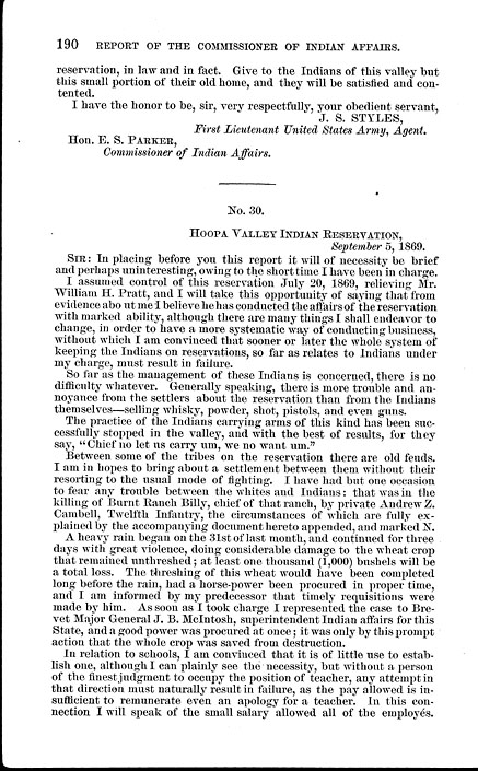
| II | Between July 20 and September 5, 1869 | 1 | Hoopa Valley Indian Reservation | Spalding to Parker, September 5, 1869 in USOIA, Report of the Commissioner of Indian Affairs, 1869, 190 | http://nahc.ca.gov/webmaster/atlas/evidence/i0640a.jpg |
TOTAL ESTIMATED NUMBER KILLED IN REGION: 2,278-3,816
*Appendix (Appx.) refers to the reference’s location in:
Benjamin Madley, An American Genocide: The United States and the California Indian Catastrophe. New Haven and London: Yale University Press, 2016.
For full bibliographical references please refer to the text or Atlas credits & references
Abbreviations used in timeline:
CSA: California State Archives, Sacramento
DAC: Daily Alta Californian newspaper (San Francisco)
DEB: Daily Evening Bulletin newspaper (San Francisco)
HL: Huntington Library
HT: Humboldt Times
IWP: California Adjutant General’s Office, Military Department, Adjutant General, Indian War Papers F3753
NARA: U.S. National Archives and Records Administration
RG75, M234: U.S. National Archives and Records Administration, “Letters Received by the Office of Indian Affairs, 1824-80”
SDU Sacramento Daily Union newspaper
USOIA U.S. Office of Indian Affairs
WOR U.S. War Department, The War of the Rebellion: A Compilation of the Official Records of the Union and Confederate Armies. 4 series, 130 volumes. Series 1, volume 50, part 1 [WOR 1:50:1], etc.
For full bibliographical references please refer to the text or Atlas credits & references