Timeline of Genocide Incidents in the Northeast California Region
CONTENT WARNING: Many of the primary sources linked on this timeline contain racist language or sentiment and graphic accounts of settler-colonial violence against indigenous people.
| Appx.* | Date | Number
reported killed
|
Location | Sources | Source Files |
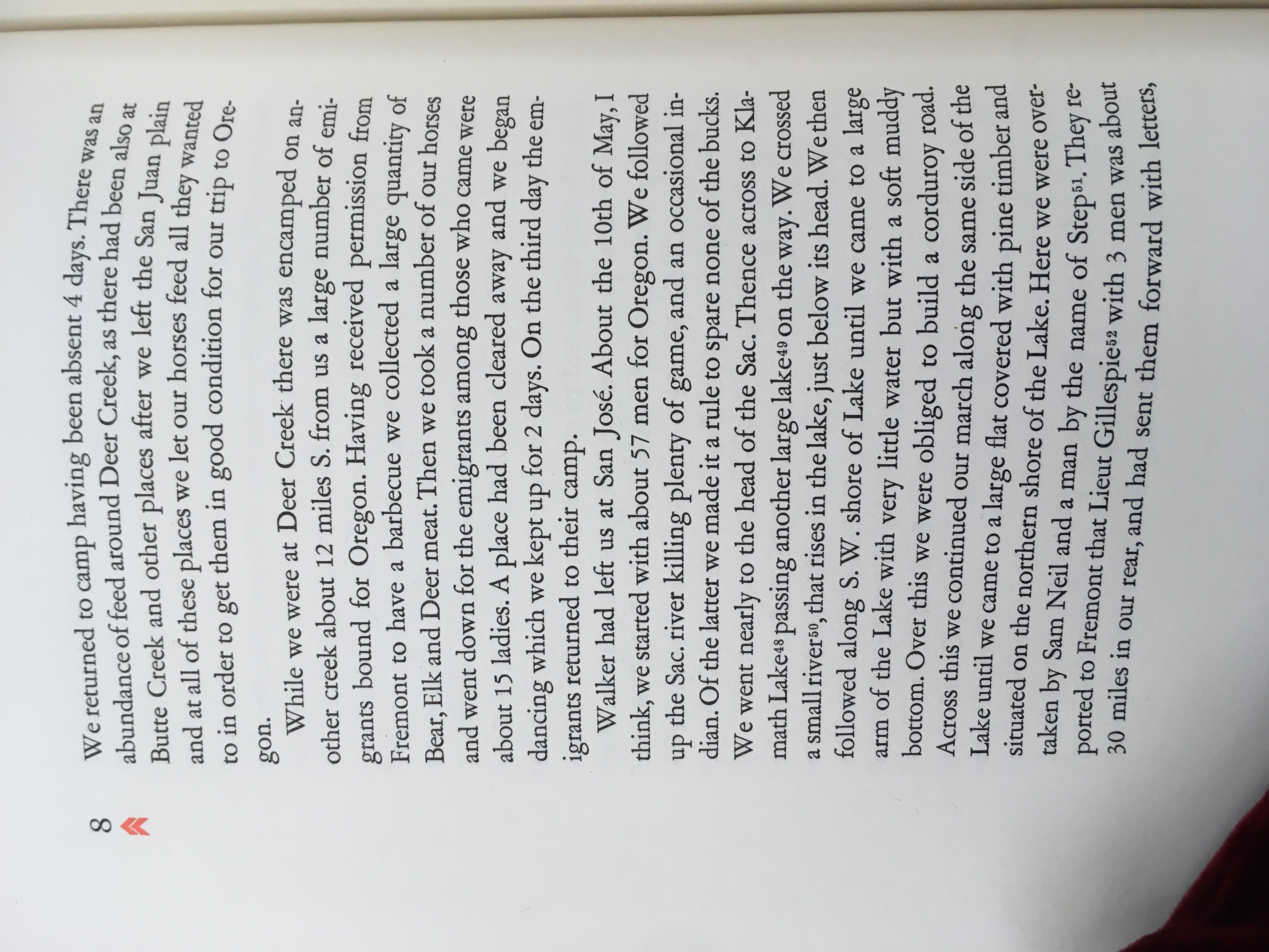
| I | After May 10, 1846 | 2+ (“an occasional indian…spar[ing] none of the bucks” en route to Oregon) | Between Lassen’s Ranch and Oregon | Martin, With Frémont to California, 8 | http://nahc.ca.gov/webmaster/atlas/evidence/i1054a.jpg |
| III | “early days,” 1850? | 0 – 93+ | “sixteen miles east of where Redding now stands” | Anonymous in Woodbridge, “Tragedy of Pit River,” 641-642. Because this is a large massacre reported long after it happened and not corroborated by other sources, it does not appear in the minimum estimated death toll for the total number of California Indians killed between 1846 and 1873 | http://nahc.ca.gov/webmaster/atlas/evidence/i0668a.pdf |
| II | March, 1850 | 1 | Middle Bar of Clear Creek | Anonymous, “California Blood Stain,” 130-131 | http://nahc.ca.gov/webmaster/atlas/evidence/i0118a.pdf |
| II | Before March 28, 1850 | 1 | “a little above Clear Creek” | Hale, March 29, 1850 journal entry in Hale Papers, Diary 4 | http://nahc.ca.gov/webmaster/atlas/evidence/i0121a.pdf |
| III | Before May 16, 1850 | 15 | “on Deer Creek” | Green to Burnett May 16, 1850 in Placer Times, May 20, 1850 2, and California, Senate Journal 1851, 763 | http://nahc.ca.gov/webmaster/atlas/evidence/i0682.pdf |
| III | Between May 22, and August 26, 1850 | 15+ | “Goose Lake country” | DAC, August 26, 1850, 2; Lyon to Canby, May 22, 1850, in S. Exec. Doc. 1, Pt 2, 31st Cong., 2nd Sess., 1850, serial 587, 83; Bancroft, Works, 24:458 | http://nahc.ca.gov/webmaster/atlas/evidence/i0696.pdf
http://nahc.ca.gov/webmaster/atlas/evidence/i0696b.pdf
|
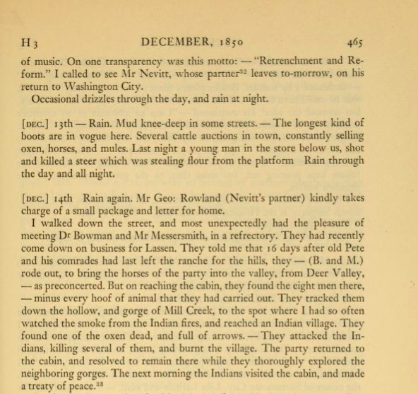
| I | November or December? of 1850 | 3 | Mill Creek | Bruff in Read and Gaines, eds., Gold Rush, 465 | http://nahc.ca.gov/webmaster/atlas/evidence/i0026a.png |
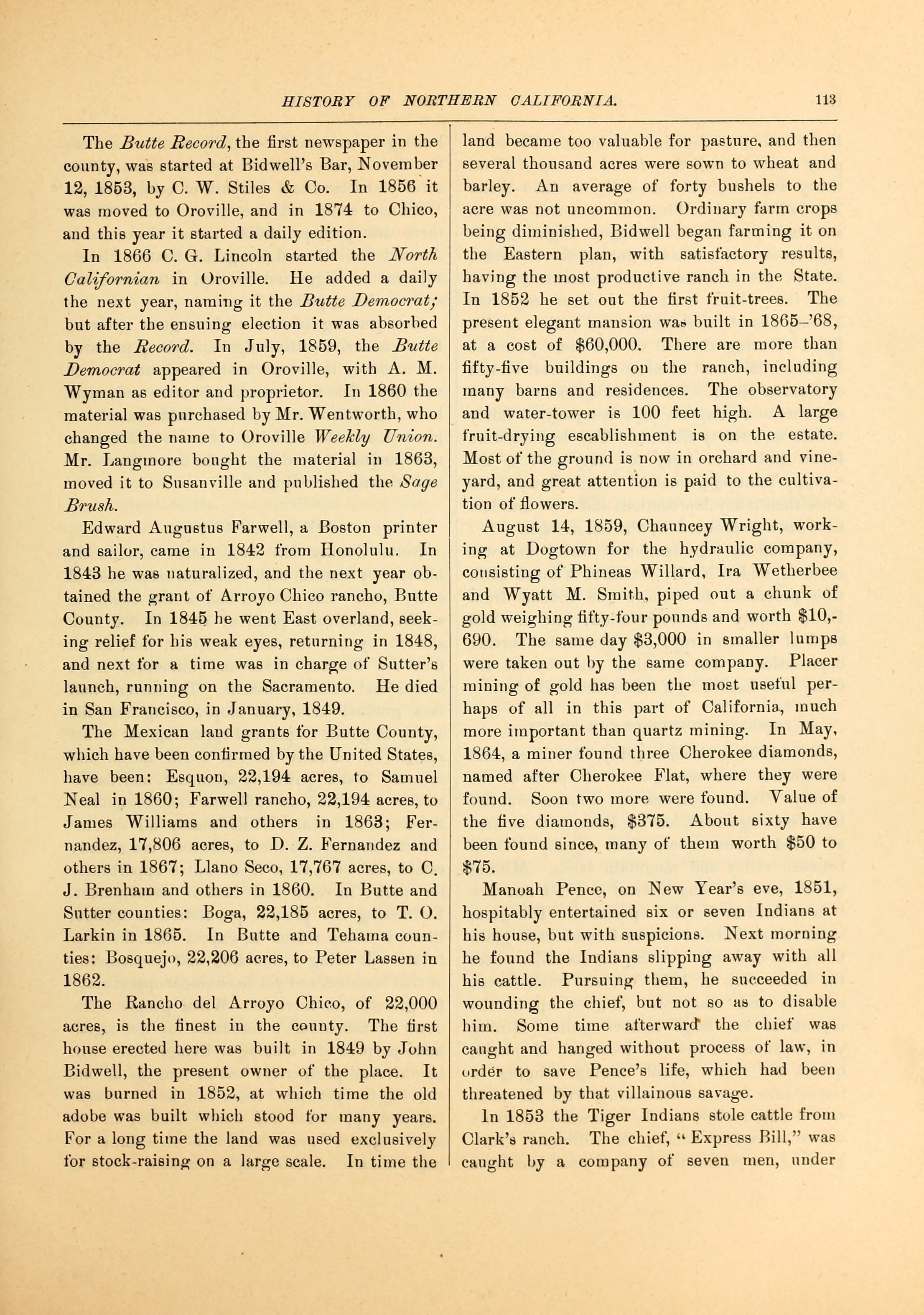
| II | After January 1, 1851 | 1 | Butte County, perhaps near Manoah Pence’s ranch | Anonymous, Memorial and Biographical History of California, Illustrated, 113 | http://nahc.ca.gov/webmaster/atlas/evidence/i0142a.jpg |
| III | Probably April or May, 1851 | 15 | “in Butte Valley 60 miles east from Yreka” | Ross, “Narrative of an Indian Fighter,” 22-23 | http://nahc.ca.gov/webmaster/atlas/evidence/i0718a.pdf |
| I | Summer of 1851 | 3 | Modoc Country | Fanning in Wells, History of Siskiyou County, 124-125 | http://nahc.ca.gov/webmaster/atlas/evidence/i0033a.pdf |
| I | Fall, 1851 | 1 | Honey Lake and Noble Pass region? | Anonymous, “Jaunt to Honey Lake Valley and Noble’s Pass,” 532 | http://nahc.ca.gov/webmaster/atlas/evidence/i0036a.pdf |
| II | Fall of 1851 | 3 | East of Lassen’s Ranch? | Anonymous, “Jaunt to Honey Lake Valley and Noble’s Pass,” 532 | http://nahc.ca.gov/webmaster/atlas/evidence/i0168a.pdf |
| III | Autumn, 1851 | 15 – 16 | “the east side of Tule Lake” or on Lost River | Kershaw in H. Mis. Doc. 47, 35th Cong., 2nd Sess., 1859, serial 1016, 41; Murray, Modocs and Their War, 19-21; Fanning in Wells, History of Siskiyou, 123-124 | http://nahc.ca.gov/webmaster/atlas/evidence/i0728a.pdf
http://nahc.ca.gov/webmaster/atlas/evidence/i0728b.pdf
|
| III | Autumn, 1851 | 15 – 20 | “in the tules near the mouth of Lost river” | Fanning in Wells, History of Siskiyou, 124-125 | http://nahc.ca.gov/webmaster/atlas/evidence/i0729a.pdf |
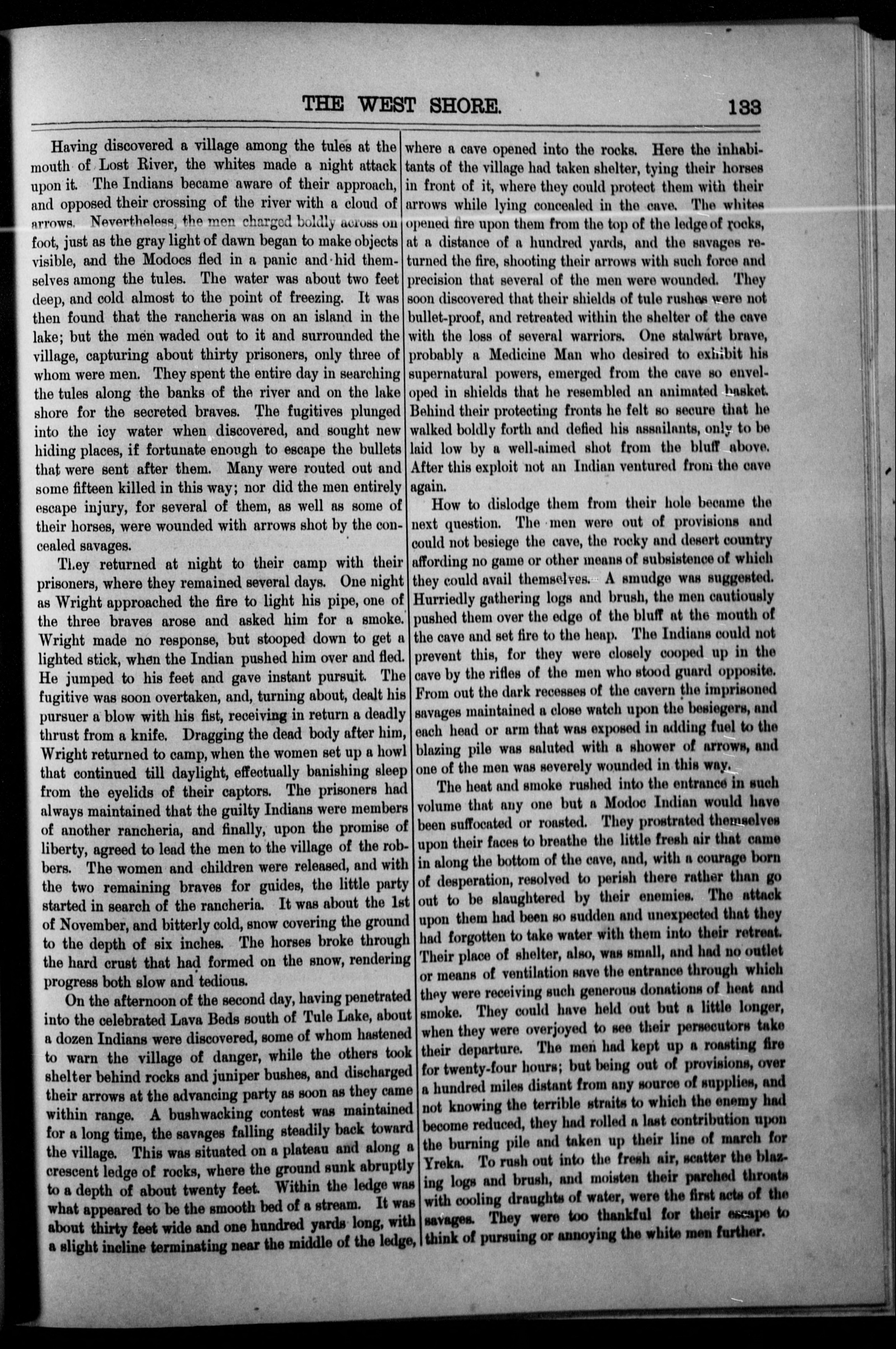
| I | November, 1851 | 3 | Lava beds south east of Tule Lake | Fanning in Wells, History of Siskiyou County, 124-125; Wells, “Modocs in 1851,” 133 | http://nahc.ca.gov/webmaster/atlas/evidence/i0035a.pdf
|
| III | Before February 17, 1852 | ~30 | Multiple locations on Pit River | SDU, February 17, 1852, 2 | http://nahc.ca.gov/webmaster/atlas/evidence/i0734.pdf |
| III | March 12, 1852 | 30 – 40 | Downriver from junction of the Scott and Klamath Rivers | McKee, March 21, 1852 in DAC, April 5, 1852, 2; March 22, 1852 letter in SDU, April 6, 1852, 3; McKee to Bigler, April 5, 1852 in California, Senate Journal, 1852, 712-713; T.J.R., May 12, 1852 in DAC, May 16, 1852, 2 | http://nahc.ca.gov/webmaster/atlas/evidence/i0738.pdf
|
| III | June 21-28, 1852 | 10 – 15 | Pit River | Cow Creek informant in SDU, June 28, 1852, 3 | http://nahc.ca.gov/webmaster/atlas/evidence/i0744.pdf |
| III | June 29, 1852 | 11 | Head of Chico Creek | SDU, July 5, 1852, 2 | http://nahc.ca.gov/webmaster/atlas/evidence/i0745.pdf |
| I | After August 24, 1852 | 3 | Between Yreka and Tule Lake | New York Times, May 24, 1873, 2. A man named Clark reported a double murder on September 1, 1852 that was almost certainly this same event. See Clark in San Francisco Chronicle, May 6, 1873, 3 | http://nahc.ca.gov/webmaster/atlas/evidence/i0039a.pdf |
| II | August 31, 1852 | 1 | Near Black Bluff and Bloody Point | Bradford, Biographical Sketches, 39 | http://nahc.ca.gov/webmaster/atlas/evidence/i0216a.pdf |
| III | August 31, 1852 | 10 – 64 | Modoc Territory | Wright to Gentlemen, September 2, 1852, IWP, F3753:203; McDermitt to Bigler, December 19, 1852 in California, Senate Journal, 1853, Document 21, 3; Correspondent, July 1, 1873 in New York Times, July 17, 1873, 2 | http://nahc.ca.gov/webmaster/atlas/evidence/i0748b.pdf |
| II | September 1, 1852 | 2 | “Not far from Klamath Lake” | Clark, April 23, 1873 in San Francisco Chronicle, May 6, 1873, 3 | |
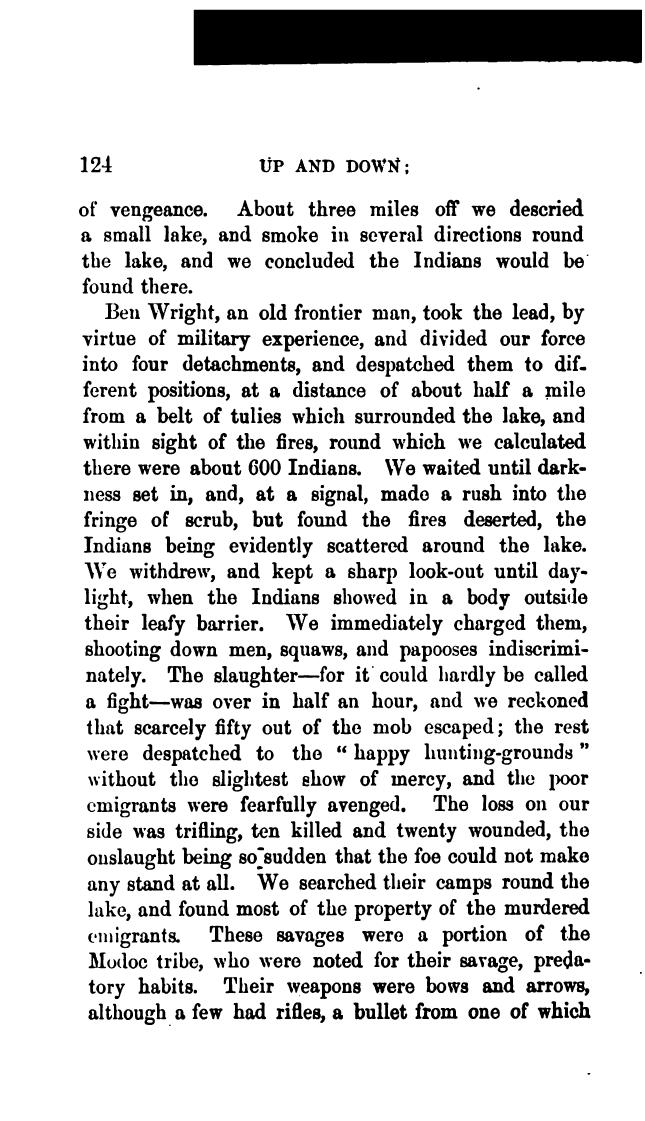
| III | 1852, probably during Wright’s August 24-November 24 Modoc Campaign | 0 – ~550 | A lake in Modoc Country | Barry, Up and Down California, 124. Because this eyewitness account described an extraordinarily large massacre but does not seem to be corroborated elsewhere, it may be an exaggeration or a fabrication. As such, this number is not included in the total low-end estimate of the number of California Indians killed between 1846 and 1873. | http://nahc.ca.gov/webmaster/atlas/evidence/i0750a.jpg |
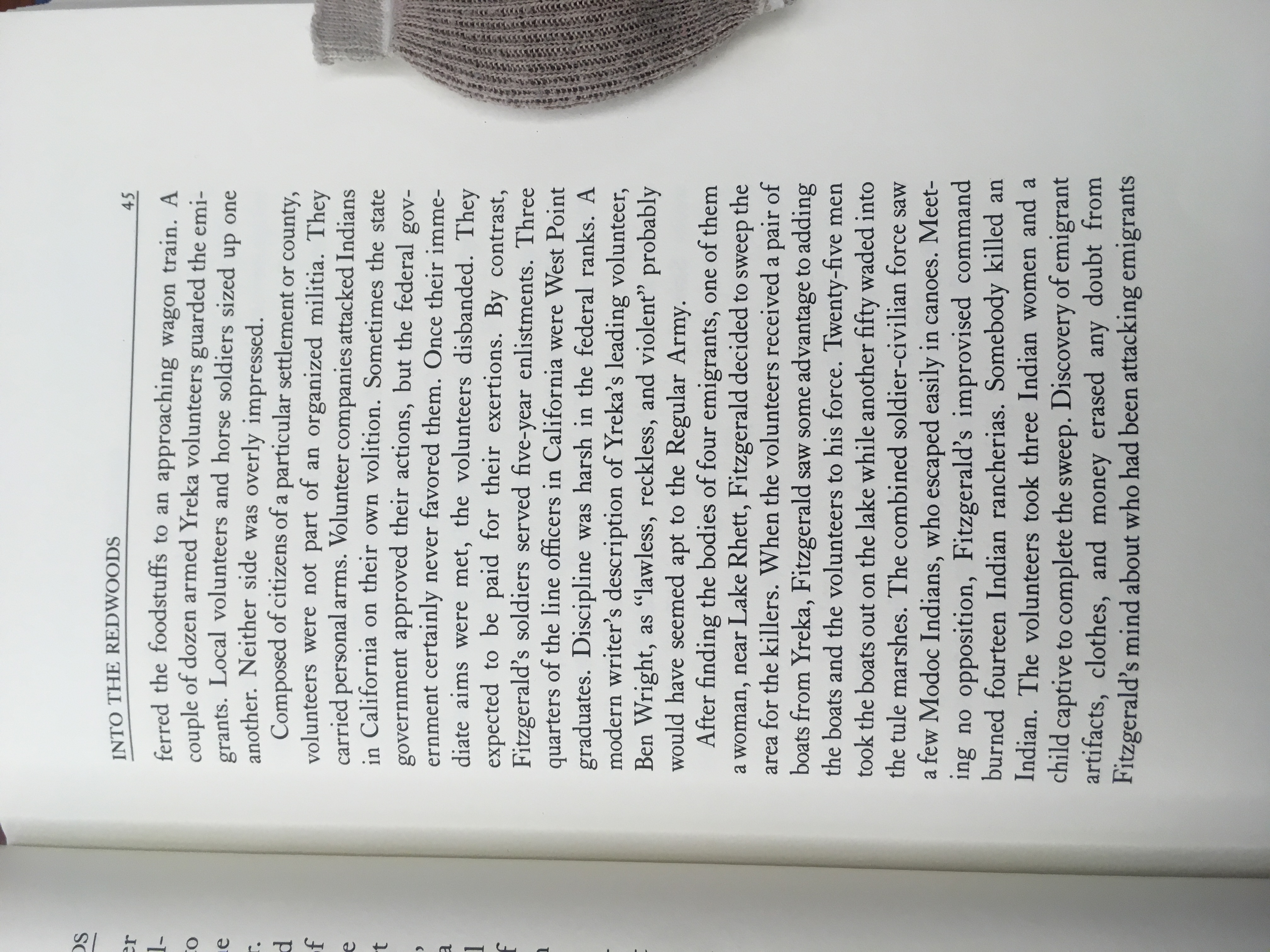
| II | October or November, 1852 | 1 | At or near Tule Lake | Strobridge, Regulars in the Redwoods, 45 | http://nahc.ca.gov/webmaster/atlas/evidence/i0221a.jpg |
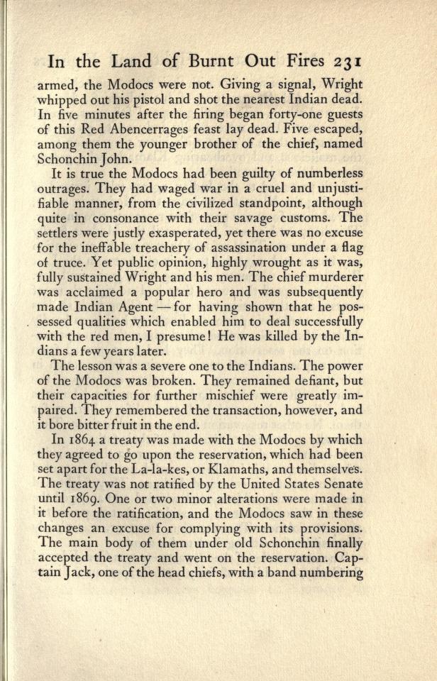
| III | November 8, 1852 | 31 – 90 | “mouth of Lost river,” probably just inside Oregon | Correspondent to Shasta Courier, November 21, 1852 in DAC, December 2, 1852, 2; MCDERMITT to BIGLER, December 19, 1852 in California, Journal of the Proceedings of the Senate, 1853, Document 21, 3; Hitchcock to Cooper, March 31, 1853, 78-79; Kershaw in H. Mis. Doc. 47, 35th Cong., 2nd Sess., 1859, serial 1016, 42; Captain Jack in Special Correspondent’s letter, May 7, 1873 in New York Times, May 24, 1873, 2; Special Correspondent’s letter, May 7, 1873 in New York Times, May 24, 1873, 2; Simpson, Meeting the Sun, 366; Wells, History, 133; Wells, “Ben Wright Massacre,” 320; Brady, Northwestern Fights and Fighters, 231; Riddle in Thompson, Reminiscences of a Pioneer, 80-83 | http://nahc.ca.gov/webmaster/atlas/evidence/i0751.pdf
|
| III | “about the year 1853” | 11 | Near “the east side of Tule Lake” | Riddle, Indian History of the Modoc War, 18-19 | http://nahc.ca.gov/webmaster/atlas/evidence/i0754a.jpg |
| III | March 11, 1853 | 8 | Near Red Bank Creek | Shasta Courier, March 26, 1852, 2; DAC, March 30, 1853, 2 | |
| II | Before March 26, 1853 | 1 | Hunt’s Ranch | Shasta Courier, March 26, 1853, 2 | |
| II | Before April 23, 1853 | 1 | “Squaw Creek” in Pit River area | Shasta Courier, April 23, 1853, 2 | |
| III | Spring of 1853 | 10+ | Near “Squaw Valley Mountain” in Pit River Region | Wells, History of Siskiyou, 134 | http://nahc.ca.gov/webmaster/atlas/evidence/i0760a.pdf |
| III | Between July 20 and July 30, 1853 | 20 – 25 | “valley watered either by M’Cloud’s or Pitt river, about 120 miles distant from Yreka” | Yreka Mountain Herald, July 30, 1853 in Shasta Courier, August 6, 1853, 2 and DAC, August 9, 1853, 2 and Placerville Herald, August 13, 1853, 2; Hutchings, January 20, 1855 journal entry, Hutchings Diary, 17-18 | http://nahc.ca.gov/webmaster/atlas/evidence/i0763b.pdf |
| II | October 4, 1853 | 2 | Near Mill Seat Creek (near Shasta?) | Shasta Courier, October 8, 1853, 2; SDU, October 10, 1853, 2 | http://nahc.ca.gov/webmaster/atlas/evidence/i0250b.jpg |
| II | Before December 3, 1853 | 3 | “near the head of Oak Run Valley” | Shasta Courier, December 3, 1853, 2; Nevada Journal, December 9, 1853, 2 | |
| II | Early February, 1854 | 2 | “near Woodman’s Ranch, on Cow Creek” | Shasta Courier, February 11, 1854, 2 in Nevada Journal, February 24, 1854, 2 | |
| III | February 17, 1854 | 9 | Near Clover Creek and Oak Run | Gardner Brooks in Shasta Courier, February 25, 1854, 2; SDU, March 2, 1854, 2 and DAC, March 3, 1854, 2 | |
| III | February 24 or 25, 1854 | 21 – 22+ | McCloud River, “only one…escaped unharmed.” | Shasta Courier, March 4, 1854, 2; SDU, March 8, 1854, 2; Shasta Courier in DAC, March 9, 1854, 2; Dreibelbis to Bigler, April 13, 1853, IWP, F3753:233 | |
| III | Between March 4 and March 7, 1854 | 1 – 22 | Near headwaters of Thomes’ Creek | Karl, March 18, 1854 in Shasta Courier, March 25, 1854, 2 | |
| III | Middle or Late March, 1854 | 14 – 17 | “between the Sacamento and McCloud rivers” (Shasta Courier) | Dreibelbis to Bigler, April 13, 1853, IWP, F3753:233; G.W., April 2, 1854 in Shasta Courier, April 8, 1854, 2, reprinted in SDU, April 11, 1854, 3 and summarized in DAC, April 12, 1854, 2 | |
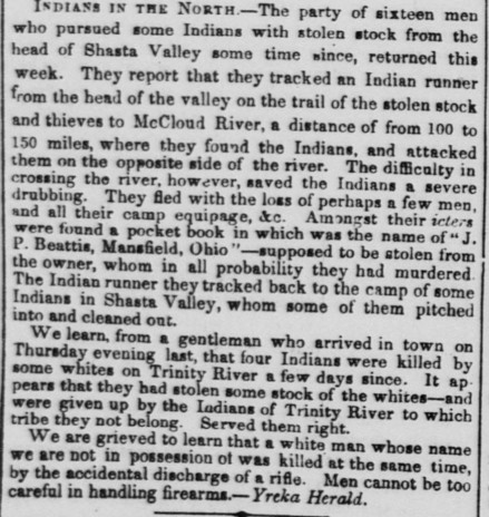
| I | April, 1854 | 0-2 | McCloud River | Yreka Herald in DAC, May 1, 1854, 2 | http://nahc.ca.gov/webmaster/atlas/evidence/i0043a.jpg |
| II | August? 1854 | 1 | Modoc Village on east side of Clear Lake | Wells, History of Siskiyou County, 137 | http://nahc.ca.gov/webmaster/atlas/evidence/i0280a.pdf |
| III | August 18-and early November, 1854 | 30 – 40 | Between Lost River/Tule Lake and the areas northeast of Goose Lake | Smith and Dennison, January 31, 1856 in H. Mis. Doc. 47, 35th Cong., 2nd Sess., 1859, serial 1016, 29; Grover and Kelly, January 13, 1857 in H. Mis. Doc. 47, 35th Cong., 2nd Sess., 1859, serial 1016, 31. See also Walker to Ross, November 6, 1854 in H. Misc. Doc. 47, 35th Cong., 2nd Sess., 1859, serial 1016, 12-13 | http://nahc.ca.gov/webmaster/atlas/evidence/i0787a.pdf |
| II | October, 1854 | 2 | Goose Lake Valley | Wells, History of Siskiyou County, 137 | http://nahc.ca.gov/webmaster/atlas/evidence/i0284a.pdf |
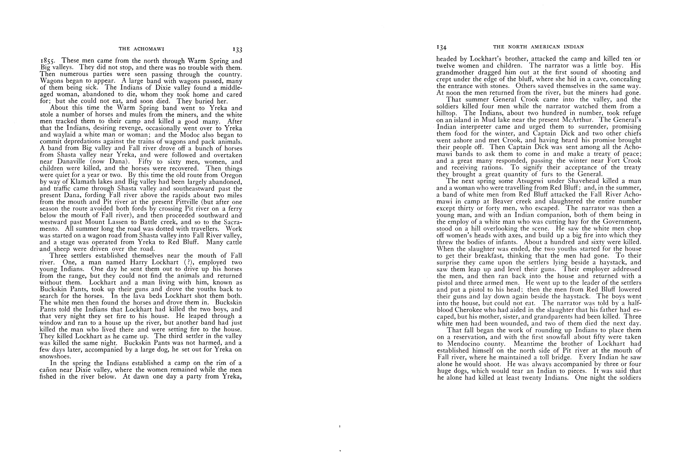
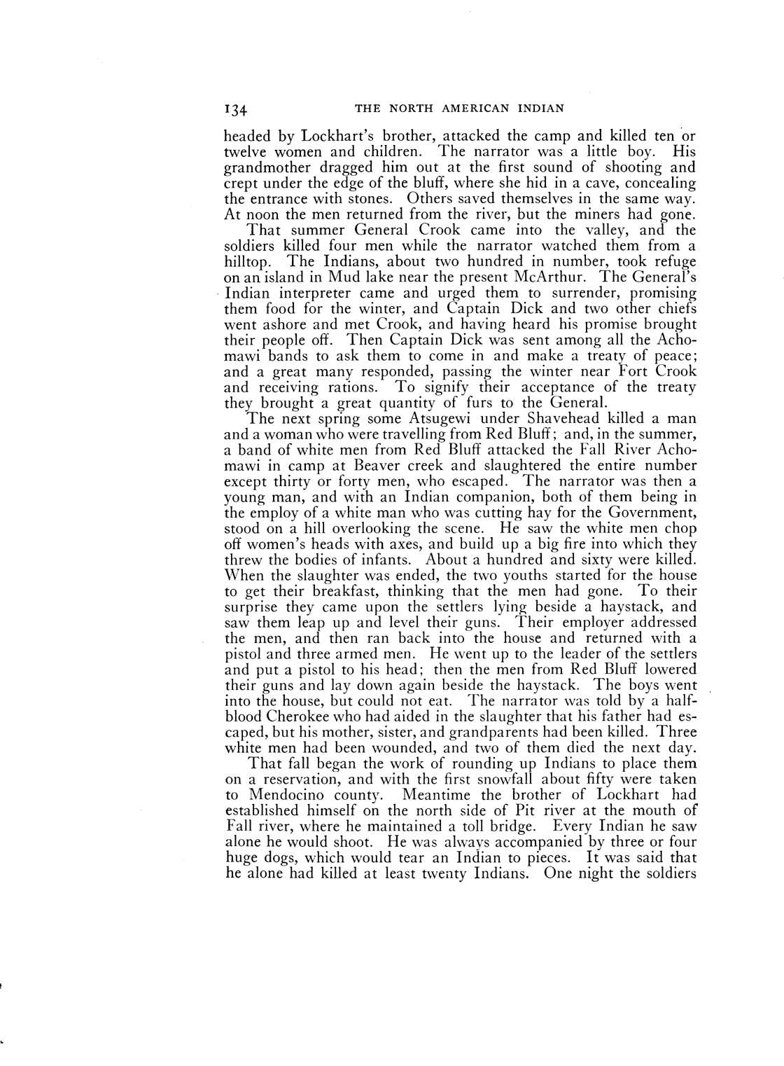
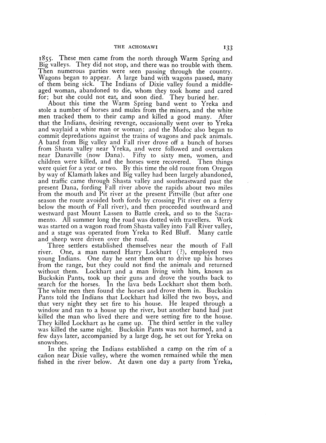
| I | 1855 | 10 | Warm Springs? | “Chief of the Fall River band” in Curtis, North American Indian, 13:133 | http://nahc.ca.gov/webmaster/atlas/evidence/i0049a.gif |
| III | 1855 | 50 – 60 | “near Danaville (now Dana)” | “Chief of the Fall River band” in Curtis, North American Indian, 13:133 | http://nahc.ca.gov/webmaster/atlas/evidence/i0791a.gif |
| III | Before October 21, 1855 | ~25 | 25 miles from Red Bluff | Bumpis summarized by Correspondent, October 21, 1855 in SDU, October 24, 1855, 2 | http://nahc.ca.gov/webmaster/atlas/evidence/i0803.pdf |
| III | December 26, 1855 | 5 | Bidwell’s Ranch, Butte County | Cowles in DAC, December 29, 1855, 2; Correspondent in SDU, December 29, 1855, 2; San Francisco Bulletin, December 29, 1855, 3 and December 31, 1855, 3 | http://nahc.ca.gov/webmaster/atlas/evidence/i0805.pdf |
| III | March, 1856 | 6 | “near Shingletown” | Shasta Republican, March 8, 1856, 2; Shasta Republican in DAC, March 12, 1856, 2 | |
| III | March, 1856 | ~30 | Near “Cold Spring Valley, which is about sixteen miles east of Red Bluffs” | Shasta Republican, March 8, 1856, 2; Shasta Republican in DAC, March 12, 1856, 2 | |
| III | April 15, 1856 | ~20 | “Harrill’s mill, on Cow Creek” | Shasta Republican, April 19, 1856, 2; Mr. Skillman in SDU, April 19, 1856, 2 and DAC, April 20, 1856, 2; San Francisco Bulletin, April 22, 1856, 1 | |
| II | April 16, 1856 | 1 | Probably Cow Creek or Oak Run | Moornan in Shasta Republican, April 19, 1856, 2 | |
| III | April 17 or 18, 1856 | 13 | “Clover Creek” | Shasta Republican, April 19, 1856, 2; San Francisco Bulletin, April 22, 1856, 1 | |
| III | A few days after July 29 or July 30, 1856 | 8 | Near Tule Lake and Bloody Point | SDU, August 11, 1856, 1; Wells, History of Siskiyou, 142 | http://nahc.ca.gov/webmaster/atlas/evidence/i0822.pdf
|
| II | July 29 or July 30, 1856 | 2 | At and near Tule Lake | SDU, August 11, 1856, 1; Wells, History of Siskiyou County, 142 | http://nahc.ca.gov/webmaster/atlas/evidence/i0328a.jpg
|
| II | A few days after July 29 or July 30, 1856 | 3 | Near Tule Lake | SDU, August 11, 1856, 1; Wells, History of Siskiyou County, 142 | http://nahc.ca.gov/webmaster/atlas/evidence/i0329a.jpg
|
| III | On or before October 3, 1856 | 26 | Tule Lake | Correspondent, October 3, 1856 in SDU, October 17, 1856, 2 | http://nahc.ca.gov/webmaster/atlas/evidence/i0827.pdf |
| II | August 7, 1856 | 1 | Pit River Region | SDU, September 2, 1856, 1 | http://nahc.ca.gov/webmaster/atlas/evidence/i0331a.jpg |
| III | On or Before October 16, 1856 | 5 | Pit River Region | SDU, October 21, 1856, 2 | http://nahc.ca.gov/webmaster/atlas/evidence/i0830.pdf |
| II | August 17 or August 18, 1856 | 2 – 3 | Island Near Bloody Point | SDU, September 2, 1856, 1; Shasta Republican, August 30, 1856, 2 | http://nahc.ca.gov/webmaster/atlas/evidence/i0332a.jpg |
| II | Between August 21 and September 4, 1856 | 4 | Great Klamath Lake, possibly in Oregon | SDU, September 17, 1856, 1 | http://nahc.ca.gov/webmaster/atlas/evidence/i0333a.jpg |
| III | August or September, 1856 | 6 | On Pit River | Judah in Shasta Republican, September 13, 1856, 2 | |
| III | August 7, 1856 | 9 – 10 | Pit River Region | SDU, September 2, 1856, 1; Shasta Republican, August 30, 1856, 2 | http://nahc.ca.gov/webmaster/atlas/evidence/i0823.pdf |
| II | September 8, 1856 | 1 | “near Hat Creek” | Shasta Courier in SDU, September 5, 1856, 4 | |
| II | September 9, 1856 | 1 | “in the vicinity of Hat Creek” | Shasta Republican, September 13, 1856, 2 | |
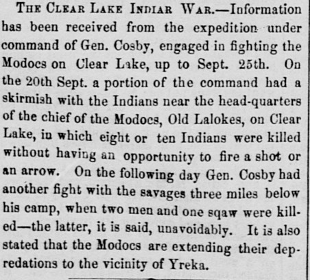
| III | September 20, 1856 | 8 – 10 | “near the headquarters of the chief of the Modocs, Old Lalakes, on Clear Lake” | SDU, October 8, 1856, 2; Butte Record, October 11, 1856, 2 | http://nahc.ca.gov/webmaster/atlas/evidence/i0825.pdf |
| II | September 21, 1856 | 3 | “three miles” from Cosby’s camp | SDU, October 8, 1856, 2; Butte Record, October 11, 1856, 2 | http://nahc.ca.gov/webmaster/atlas/evidence/i0337a.jpg |
| II | Before September 29, 1856 | 5 in multiple attacks | Pit River region | SDU, October 17, 1856, 2 | http://nahc.ca.gov/webmaster/atlas/evidence/i0338.pdf |
| III | Late January or early February, 1857 | 5 | Lockhart’s Ferry, Pit River | Butte Record, February 21, 1857, 2, May 2, 1857, 3; Shasta Republican, February 14, 1857, 2 | |
| II | March 25, 1857 | 1 | Pit River | Fox in Yreka Union in Butte Record, May 2, 1857, 3 | |
| II | ~April 1, 1857 | 1 | Pit River Valley | Shasta Republican, April 11, 1857, 2 | |
| III | Likely April, 1857 | 10 – 12 (“women and children”) | “on the rim of a canon near Dixie valley” | “Chief of the Fall River band” in Curtis, North American Indian, 13:133-134 NOTE: This massacre may be the same one described above | http://nahc.ca.gov/webmaster/atlas/evidence/i0836a.gif |
| III | April 7, 1857 | 16 | Pit River | Fox in Butte Record, May 2, 1857, 3 | |
| III | Between ~April 1 and May 1, 1857 | 59 (including a massacre committed between April 18 and May 1, 1857) | Summary of the Mounted Volunteers of Siskiyou County Expedition in the Pit River region | Yreka Union, May 7, 1857, in SDU, May 12, 1857, 1. Note: this figure is used only to calculate the low-end total numbers of California Indians killed as other sources suggest that this expedition may have killed as many as seventy-two people. | http://nahc.ca.gov/webmaster/atlas/evidence/i1071.pdf |
| II | Before April 21, 1857 | 3 | “about ten or twelve miles up the East Fork of Pitt River, above the Ferry” | Lockhart to Shasta Courier, April 21, 1857 in SDU, April 28, 1857, 2; Fox in Yreka Union in Butte Record, May 2, 1857, 3 | |
| III | Between April 18 and May 1, 1857 | 59 | Pit River Region | Yreka Union, May 7, 1857 in SDU, May 12, 1857, 1 | |
| II | After May 27, 1857 | 1 | Pit River region | Crook, General George Crook, 39 | http://nahc.ca.gov/webmaster/atlas/evidence/i0349a.pdf |
| II | Before June 20, 1857 | 1 | Near Yreka Road in Pit River region | Oldom summarized in Butte Record, June 20, 1857, 3 | |
| II | June 26, 1857 | 1 | Pit River | Yreka Union, July 2, 1857 in SDU, July 8, 1857, 2 | http://nahc.ca.gov/webmaster/atlas/evidence/i0353.pdf |
| II | After June 27, 1857 | 2 | Pit River region | Crook, General George Crook, 43 | http://nahc.ca.gov/webmaster/atlas/evidence/i0354a.pdf |
| III | July 2, 1857 | 35+ | “about twenty-five miles from” Fort Crook | Saunders in Yreka Union, July 16, 1857 in SDU, July 20, 1857, 2 and DAC, July 23, 1857, 1 | http://nahc.ca.gov/webmaster/atlas/evidence/i0840.pdf |
| II | July 4, 1857 | 1 | Pit River region | Crook, General George Crook, 45 | http://nahc.ca.gov/webmaster/atlas/evidence/i0355a.pdf |
| III | June 7, 1857 | 3 – 5 | “some twenty-five miles above the ferry on Pitt River” | Shasta Republican, June 20, 1857, 3; Siskiyou Chronicle in Butte Record, June 27, 1857, 3 | |
| III | July 7, 1857 | 21 | Pit River Region | C. in Shasta Republican, July 18, 1857, 2 | |
| II | Before July 11, 1857 | 1 | Pit River region | Dryer in Butte Record, July 11, 1857, 4 | |
| III | June 15, 1857 | 2 – 50+ | “about four miles above Lassen’s cabin…in Mill creek canon” in addition to running fight down-canyon | Red Bluff Beacon, June 17, 1857, 2; Red Bluff Beacon and Chaffee in Shasta Republican, June 20, 1857, 2, reprinted in DAC, June 22, 1857, 2 and SDU, June 20, 1857, 2 | http://nahc.ca.gov/webmaster/atlas/evidence/i0839.pdf |
| III | July 25, 1857 | 23+ – 30 | 60 miles east of Fort Crook or “forty miles above Fort Crook” | Yreka Union in Shasta Republican, August 8, 1857, 2 and SDU, August 5, 1857, 2; Sanders in SDU, August 4, 1857, 2 | http://nahc.ca.gov/webmaster/atlas/evidence/i0842.pdf |
| II | Between July 7, and July 11, 1857 | 2 | Pit River region | Dryer in Butte Record, July 11, 1857, 4; Yreka Union in SDU, August 5, 1857, 2 and Shasta Republican August 8, 1857, 2 | |
| II | Summer, 1857 | 4 | Pit River region | “Chief of the Fall River band” in Curtis, North American Indian, 13:134 | http://nahc.ca.gov/webmaster/atlas/evidence/i0350a.gif |
| II | August, 1857 | 2 | “in the Hat Creek country” | McCall in Yreka Chronicle, August 27, 1857 in SDU, September 1, 1857, 3; Shasta Republican, September 5, 1857, 2 | |
| II | Late September, 1857 | 1 | “on Battle Creek” near present-day Redding | Shasta Republican in SDU, September 29, 1857, 2 and DAC, October 1, 1857, 1 | http://nahc.ca.gov/webmaster/atlas/evidence/i0366.pdf |
| III | October 17, 1857 | 7 – 11 | Southern end of Honey Lake Valley | Fairfield, Fairfield’s Pioneer History of Lassen County…, 85; J. Williams in SDU, October 24, 1857, 2; Shasta Republican, October 31, 1857, 4 | http://nahc.ca.gov/webmaster/atlas/evidence/i0843a.jpg |
| II | Before October 19, 1857 | 3 | Honey Lake Valley | Fairfield, Fairfield’s Pioneer History of Lassen County…, 83 | http://nahc.ca.gov/webmaster/atlas/evidence/i0368a.jpg |
| II | Before November 4, 1857 | 4 | “on Battle Creek, in Tehama county” | Red Bluff Beacon, November 4, 1857 in SDU, November 6, 1857, 3; DAC, November 7, 1857, 2; DEB, November 9, 1857, 3 | http://nahc.ca.gov/webmaster/atlas/evidence/i0369.pdf |
| II | Winter of 1857-1858 | 2 | “the lava beds” near Lockhardt’s Ferry | “Chief of the Fall River band” in Curtis, North American Indian, 13:133 | http://nahc.ca.gov/webmaster/atlas/evidence/i0371a.gif |
| III | “several days” before February 2, 1858 | 10 – 12 | Likely between a point “a few miles south of Smith’s Ranch on the Yreka road, Shasta County” and Antelope Creek | Red Bluff Beacon, February 2, 1858, 2 | |
| II | Early April, 1858 | 2 | Somewhere near Honey Lake | Roop in Shasta Republican, May 8, 1858, 1; DAC, May 13, 1858, 1 | http://nahc.ca.gov/webmaster/atlas/evidence/i0383.pdf |
| II | On or before April 20, 1858 | 1 | Honey Lake Valley | Correspondent to SDU, May 4, 1858, 2 | http://nahc.ca.gov/webmaster/atlas/evidence/i0385.pdf |
| I | Spring of 1858 | 10 | On or near Antelope Creek | Delaney, “Adventures of Captain Hi Good,” 1 | http://nahc.ca.gov/webmaster/atlas/evidence/i0056a.pdf |
| II | Between April 18 and May 6, 1858 | 4 | Grasshopper Valley, north of Honey Lake Valley | Dow and Hines in Fairfield, Fairfield’s Pioneer History of Lassen County…, 114-115 | http://nahc.ca.gov/webmaster/atlas/evidence/i0384a.pdf |
| III | Between April 28 and May 5, 1858 | ~15 | Battle Creek | Red Bluff Beacon, May 5, 1858, 2 reprinted in SDU, May 7, 1858, 1, DEB, May 8, 1858, 3 and DAC, May 9, 1858, 1 | http://nahc.ca.gov/webmaster/atlas/evidence/i0850.pdf |
| III | Before May 3, 1858 | 40 – 50 | “near ‘Lassen’s Peak’” | Correspondent, May 3, 1858 in SDU, May 6, 1858, 1 | http://nahc.ca.gov/webmaster/atlas/evidence/i0849.pdf |
| III | May 6, 1858 | 17 – 50 | Goose Lake | Oroville Advertiser in DAC, May 9, 1858, 1; Garlow in Butte Record, May 10, 1858 reprinted in SDU, May 12, 1858, 2, DAC, May 13, 1858, 1 and Shasta Republican, May 15, 1858, 2; Adams summarized in Red Bluff Beacon, May 26, 1858, 2; Dow and Hines in Fairfield, Fairfield’s Pioneer History of Lassen County…, 116-119 | http://nahc.ca.gov/webmaster/atlas/evidence/i0851.pdf
|
| II | May 18, 1858 | 1 | Battle Creek | Red Bluff Beacon, May 19, 1858, 2, reprinted in SDU, May 21, 1858, 3 | http://nahc.ca.gov/webmaster/atlas/evidence/i0388.pdf |
| II | Before May 19, 1858 | 1 | “Antelope Canyon” | Red Bluff Beacon, May 19, 1858, 2, reprinted in SDU, May 21, 1858, 3 | http://nahc.ca.gov/webmaster/atlas/evidence/i0389.pdf |
| II | June 5, 1858 | 1 | “Kinshew tribe, at Crane Valley” | Letter, June 6 in Marysville News in SDU, June 9, 1858, 2 | http://nahc.ca.gov/webmaster/atlas/evidence/i0394.pdf |
| II | Early August, 1858 | 1 | “near Antelope mills” | Red Bluff Beacon, August 25, 1858, 2; DAC, August 28, 1858, 1 | http://nahc.ca.gov/webmaster/atlas/evidence/i0398.pdf |
| II | Before November 20, 1858 | 2 | “near Squaw Creek” | Shasta Courier, November 20, 1858 in SDU, November 22, 1858, 1; DAC, November 23, 1858, 1 | http://nahc.ca.gov/webmaster/atlas/evidence/i0405.pdf |
| III | January 23, 1859 | “10-12” | “in Shasta county” | Shasta Courier, January 29, 1859, 2, reprinted in DAC, February 2, 1859, 1; SDU, February 1, 1859, 3; Red Bluff Beacon, February 2, 1859, 2 | http://nahc.ca.gov/webmaster/atlas/evidence/i0871.pdf |
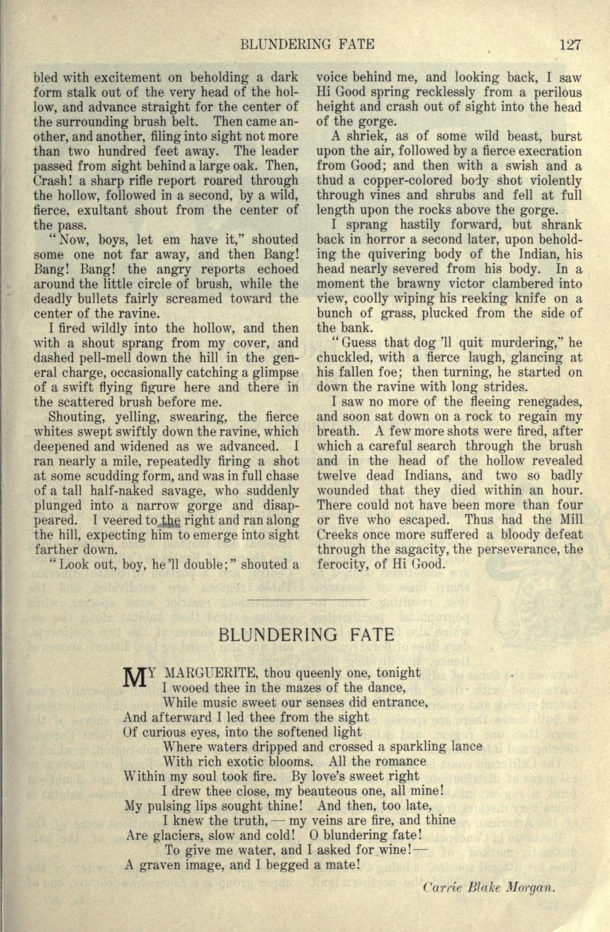
| III | March, 1859 | 14 | “Grapevine” on the edge of Mill Creek | Sauber, “True Tales of the Old West, XV— Hi Good and the ‘Mill Creeks,’” 127 | http://nahc.ca.gov/webmaster/atlas/evidence/i0874a.jpg |
| III | After June 15, 1859 | 41 | South of Chico Creek | Anderson, Fighting the Mill Creeks, 22-24 | http://nahc.ca.gov/webmaster/atlas/evidence/i0884a.pdf |
| III | Between July 24 and July 31, 1859 | 5 | “between the headwaters of Butte and Deer Creeks” | Red Bluff Beacon, August 3, 1859, 2, reprinted in SDU, August 5, 1859, 4 and DEB, August 6, 1859, 3 | http://nahc.ca.gov/webmaster/atlas/evidence/i0885.pdf |
| III | Between July 24 and July 31, 1859 | 10 | At or near the area “between the headwaters of Butte and Deer Creeks” | Red Bluff Beacon, August 3, 1859, 2, reprinted in SDU, August 5, 1859, 4 and DEB, August 6, 1859, 3 | http://nahc.ca.gov/webmaster/atlas/evidence/i0886.pdf |
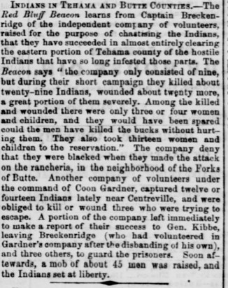
| III | July 28, 1859 | 9+ | ~2 miles from “Forks of Butte” | Correspondent, Forks of Butte, July 28, 1859 in SDU, August 6, 1859, 2, reprinted in DAC, August 8, 1859, 1; Butte Herald correspondent, July 29, 1859 in DAC, August 9, 1859, 1 and DEB, August 8, 1859, 3; Citizens of the Forks of Butte in SDU, August 20, 1859, 1 | http://nahc.ca.gov/webmaster/atlas/evidence/i0887.pdf |
| III | Before August 27, 1859 | 13 | Fort Crook Region | Shasta Herald, August 27, 1859, 2 | |
| III | Before August 30, 1859 | 21 | Pit River region (?) | Shasta Courier in DAC, August 30, 1859, 2 and DEB, August 31, 1859, 2 | http://nahc.ca.gov/webmaster/atlas/evidence/i0893.pdf |
| II | August or September, 1859 | 2 | Rock Creek Canyon region | Disbanded Volunteer in Red Bluff Beacon, December 14, 1859, 2 | http://nahc.ca.gov/webmaster/atlas/evidence/i0434.pdf |
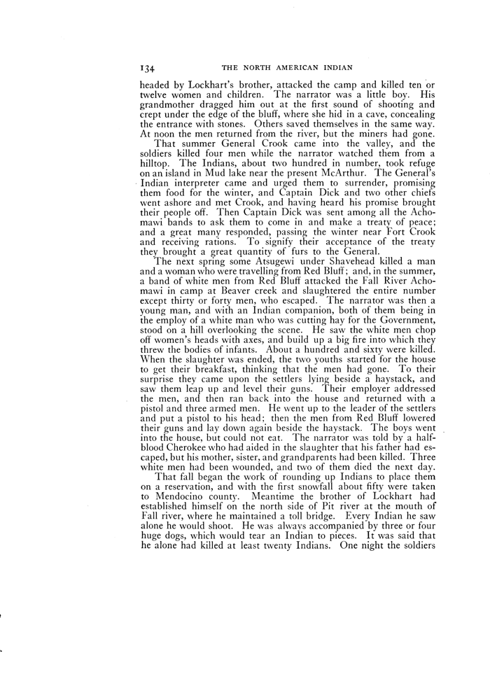
| I | After September 3, 1859 | 3 | Fort Crooks tribe | DAC, January 26, 1860, 1 | http://nahc.ca.gov/webmaster/atlas/evidence/i0059a.pdf |
| I | After September 3, 1859 | 3 | “near Fall River” | DAC, January 26, 1860, 1 | http://nahc.ca.gov/webmaster/atlas/evidence/i0060a.pdf |
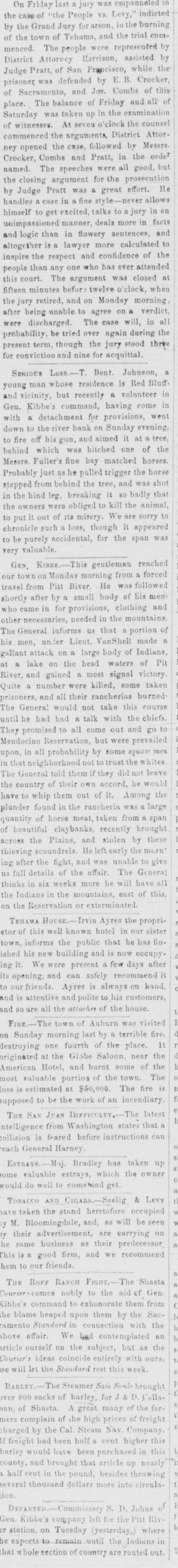
| III | September 3, 1859 | 62 – 160 | Rolf’s Ranch, Beaver Creek, Pit River Valley | Shasta Courier, September 17, 1859, 2; Yount in Daily Alta California in SDU, January 30, 1860, 1; Kibbe volunteer, October 8, 1859 in Trinity Journal, October 15, 1859, 2, reprinted in SDU, October 19, 1859, 2; Telegram, September 6, 1859 in SDU, September 7, 1859, 2, DEB, September 8, 1859, 3, and DAC, September 9, 1859, 1; Shasta Herald, September 10, 1859, 2; Landt in Plumas Argus, October 1, 1859 in SDU, October 4, 1859, 1, DEB, October 5, 1859, 3, DAC, October 6, 1859, 1; “Chief of the Fall River band” in Curtis, North American Indian, 13:134 | http://nahc.ca.gov/webmaster/atlas/evidence/i0894g.gif |
| III | Multiple Incidents after September 3, 1859 | 20 | Region near “the north side of Pit river at the mouth of Fall river” | “Chief of the Fall River band” in Curtis, North American Indian, 13:134 | http://nahc.ca.gov/webmaster/atlas/evidence/i0895a.gif |
| I | Before September 5, 1859 | 0-3 | Near Centerville | Red Bluff Beacon in DAC, September 5, 1859, 1 | http://nahc.ca.gov/webmaster/atlas/evidence/i0061a.jpg |
| II | Before September 10, 1859 | 1-2 | “Hat Creek Country” | Hazlett, in Shasta Herald, September 19, 1859, 2. | |
| II | Before September 11, 1859 | 4 – 5 | Unreported | Telegram in DAC, September 11, 1859, 1; Shasta Herald, September 17, 1859, 2; Yreka Union in Butte Democrat, September 17, 1859, 3; Yreka Union in DEB, September 28, 1859, 3 | http://nahc.ca.gov/webmaster/atlas/evidence/i0435.pdf |
| II | Before September 28, 1859 | 2 | “Near Lockhart’s Ferry” | Yreka Union in DEB, September 28, 1859, 3 | |
| II | Before October 1, 1859 | 2 | At or near Roff’s Ranch, following the massacre there | Landt in Plumas Argus, October 1, 1859 in DAC, October 6, 1859, 1. | http://nahc.ca.gov/webmaster/atlas/evidence/i0437.pdf |
| III | October 5, 1859 | 6 | Northeast shores of Eagle Lake | S., October 10, 1859 in Red Bluff Beacon, October 26, 1859, 1, reprinted in Shasta Herald, October 29, 1859, 2 and SDU, October 28, 1859, 2 | http://nahc.ca.gov/webmaster/atlas/evidence/i0898.pdf |
| I | On or before October 10, 1859 | 10 | “at a lake on the head waters of Pitt [sic] river” | Kibbe in Red Bluff Beacon, October 12, 1859, 2, summarized in DAC, October 15, 1859, 1 | http://nahc.ca.gov/webmaster/atlas/evidence/i0062a.jpg |
| III | August 16-December 25, 1859 | ~200 | Complete Pit River Expedition Summary | Kibbe, Report of the Expedition Against the Indians in the Northern Part of this State, 7; Red Bluff Beacon, December 7, 1859, 2; Shasta Herald, January 21, 1860, 2 | http://nahc.ca.gov/webmaster/atlas/evidence/i0909a.pdf |
| III | Before October 26, 1859 | 23 | Summary of Indians killed by “Shasta volunteers,” in northeastern California | Belden in Plumas Standard in SDU, October 26, 1859, 3 and Butte Democrat, October 29, 1859, 2 | http://nahc.ca.gov/webmaster/atlas/evidence/i0900.pdf |
| III | November 1, 1859 | 80 (men) | Summary of Pit River Expedition (militia) | H.W.S., November 1, 1859 in SDU, November 8, 1859, 3 | http://nahc.ca.gov/webmaster/atlas/evidence/i0901.pdf |
| I | Before mid-December, 1859 | 3 | “the Indian stronghold” in the Pit River and Hat Creek region | Kibbe, Report, 56-57 (in edition located, original pp 6-7) | http://nahc.ca.gov/webmaster/atlas/evidence/i0063a.pdf |
| III | February, 1860 | 3 – 17 | Black Rock, Mill Creek Canyon | Kauffman, “Nosea Indians,” Newspaper clipping ca.1882, Gans Scrapbook | |
| II | May, 1860 | 1 | “Butte Creek” | Brown in SDU, June 12, 1860, 3 | http://nahc.ca.gov/webmaster/atlas/evidence/i0454.pdf |
| II | May, 1860 | 3 – 4 | “the house of a Mr. Baker, sixty miles from Yreka, in the Modoc country” | Scott in DAC, January 6, 1861, 1 | http://nahc.ca.gov/webmaster/atlas/evidence/i0455.pdf |
| II | Before May 12, 1860 | 1 | “near Clear Creek, on the Klamath” River | Northern Californian in DAC, May 12, 1860, 1; HT, May 12, 1860, 2 | http://nahc.ca.gov/webmaster/atlas/evidence/i0451.pdf |
| III | May 24, 1860 | 5 | Butte Valley, “about twenty-five miles east of Yreka” | May 25 letter in DAC, May 26, 1860, 1 and SDU, May 26, 1860, 2 | http://nahc.ca.gov/webmaster/atlas/evidence/i0926.pdf |
| II | Before June 13, 1860 | 1 | Near “the road between the Sacramento River and Hat Creek” | Red Bluff Beacon, June 13, 1860 in DAC, June 16, 1860, 1 | http://nahc.ca.gov/webmaster/atlas/evidence/i0457.pdf |
| II | Before June 16, 1860 | 4 | Near “the road between Sacramento River and Hat Creek” | Red Bluff Beacon in Shasta Herald, June 16, 1860, 2; HT, June 30, 1860, 2 | http://nahc.ca.gov/webmaster/atlas/evidence/i0458.pdf |
| II | Before June 25, 1860 | 1 | 25 miles south of Klamath Reservation | Northern Californian in SDU, June 25, 1860, 4 | http://nahc.ca.gov/webmaster/atlas/evidence/i0459.pdf |
| II | Before October 6, 1860 | 1 | On McCloud River | Shasta Courier, October 6, 1860 in SDU, October 9, 1860, 1, DEB, October 11, 1860, 2 and DAC, October 11, 1860, 1 | http://nahc.ca.gov/webmaster/atlas/evidence/i0465.pdf |
| II | Before January 11, 1861 | 1 | Pit River Valley | SDU, February 19, 1861, 2 | http://nahc.ca.gov/webmaster/atlas/evidence/i0471.pdf |
| II | Before May 9, 1861 | 4 | “Mill Creek, in Tehama County” | Shasta Herald, May 9, 1861 in Marysville Appeal, May 12, 1861, 2; Shasta Herald, May 11(?), 1861 in DEB, May 15, 1861, 1 | |
| II | August 5, 1861 | 1 | “Upper Pitt River Valley” | WOR, 1:50:1, 22-23 | http://nahc.ca.gov/webmaster/atlas/evidence/i0489a.pdf |
| II | Mid-December, 1861 | 1 | “a couple of miles southeast of Janesville” | Cain and Lomas in Fairfield, Fairfield’s Pioneer History of Lassen County…, 248-249 | http://nahc.ca.gov/webmaster/atlas/evidence/i0499a.pdf |
| II | March 30, 1862 | 2 | Lathrop Ranch, Honey Lake Valley | Harper, Asbury, and Tunison in Fairfield, Fairfield’s Pioneer History of Lassen County…, 280-281 | http://nahc.ca.gov/webmaster/atlas/evidence/i0503a.pdf |
| I | July 1, 1862 | 3 | Yahi Yana Territory | Butte Record, July 5, 1862, 2, reprinted in SDU, July 7, 1862, 4; Anderson, Fighting the Mill Creeks, 55 | http://nahc.ca.gov/webmaster/atlas/evidence/i0074a.jpg
|
| III | Summer, 1862 | 8 | East of Red Bluff | Anderson, Fighting the Mill Creeks, 55 | http://nahc.ca.gov/webmaster/atlas/evidence/i0979a.jpg |
| II | Early August, 1862 | 1 | “near Thoms Creek” | Rogers, Colusa County, 93 | |
| II | August 3, 1862 | 1 | “fifteen or twenty miles east of Red Bluff” on or near “Big Antelope” Creek | Red Bluff Semi-weekly Independent, August 8, 1862, 2 | http://nahc.ca.gov/webmaster/atlas/evidence/i0525.pdf |
| III | August 4, 1862 | 23 – 25 | “Big Antelope” Creek or “the head of Antelope Creek” | Red Bluff Beacon, August 7, 1862, 2; Red Bluff Semi-Weekly Independent, August 8, 1862, 2; Marysville Daily Appeal, August 9, 1862, 2; SDU, August 21, 1862, 2; Delaney in Northern Enterprise, June 7, 1872, 2; Anderson, Fighting the Mill Creeks, 55 | http://nahc.ca.gov/webmaster/atlas/evidence/i0982.pdf
|
| II | August 14, 1862 | 4 | Mill Creek | Good, August 18, 1862 in Red Bluff Beacon, August 21, 1862, 3; SDU, August 21, 1862, 2 | http://nahc.ca.gov/webmaster/atlas/evidence/i0526.pdf |
| II | September 26, 1862 | 1 | “about half a mile west of Fort Janesville” | Fairfield, Fairfield’s Pioneer History of Lassen County…, 289-290 | http://nahc.ca.gov/webmaster/atlas/evidence/i0527a.pdf |
| III | November 17, 1862 | 11+ (“seven Indians, and squaws and papooses”) | Near Pit River and “Tula valley” | Tunison in Fairfield, Fairfield’s Pioneer History of Lassen County, 293-294 | http://nahc.ca.gov/webmaster/atlas/evidence/i0985a.pdf |
| II | Before March 12, 1863 | 3 | “seven or eight miles above Chico” | Oroville Union, March 14, 1863 in SDU, March 16, 1863, 3 | http://nahc.ca.gov/webmaster/atlas/evidence/i0533.pdf |
| II | June, 1863 | 3 | Deer Creek region | Delaney, “Adventures of Captain Hi Good,” 1 | http://nahc.ca.gov/webmaster/atlas/evidence/i0541a.pdf |
| III | June, 1863 | 7 | Near “the breaks of Mill Creek” | Anderson, Fighting the Mill Creeks, 66, 70 | http://nahc.ca.gov/webmaster/atlas/evidence/i1001a.pdf |
| III | June 7 or 8, 1863 | 5 | Helltown, Butte County | Correspondent in SDU, June 11, 1863, 2; Wells and Chambers, History of Butte County, 219 | http://nahc.ca.gov/webmaster/atlas/evidence/i1002b.pdf |
| II | July 24, 1863 | 3 | “near Hupp & Co.’s mills” in Butte County | Oroville Union, August 1, 1863 in Bancroft Scraps, 36:116 and San Francisco Bulletin, August 6, 1863, 2 | http://nahc.ca.gov/webmaster/atlas/evidence/i0551a.pdf |
| II | Late April, 1864 | 1 | Round Mountain, 40 miles from Fort Crook | WOR, 1:50:2, 566 | http://nahc.ca.gov/webmaster/atlas/evidence/i0577a.pdf |
| II | Before June 13, 1864 | 1 | “Millville, Shasta county” | SDU, June 13, 1864, 2 | http://nahc.ca.gov/webmaster/atlas/evidence/i0581.pdf |
| III | Before August 13, 1864 | 12+ | Ten miles northwest of Surprise Valley “in the direction of Goose Lake.” | Snow Shoe, Susanville to Editors Appeal, August 13, 1864 in Marysville Daily Appeal, August 23, 1864, 2 | http://nahc.ca.gov/webmaster/atlas/evidence/i1018.pdf |
| II | Early September, 1864 | 2 – 3 | Oak Run | Ayres, “NOTES,” 3 | http://nahc.ca.gov/webmaster/atlas/evidence/i0584a.pdf |
| II | Early September, 1864 | 1 | “about two miles above the mill on Cow Creek” | Ayres, “NOTES,” 3 | http://nahc.ca.gov/webmaster/atlas/evidence/i0585a.pdf |
| III | September, 1864 | 300 | North of Millville | Curtin, Creation Myths, 519 | http://nahc.ca.gov/webmaster/atlas/evidence/i1020a.pdf |
| I | Probably September or October, 1864 | 1 | Bear Creek | Informant in Waterman, “Yana Indians,” 51 | http://nahc.ca.gov/webmaster/atlas/evidence/i0080a.pdf |
| II | September or October, 1864 | 3 | “Millville” | Curtin, Creation Myths, 517-518 | http://nahc.ca.gov/webmaster/atlas/evidence/i0587a.pdf |
| II | September or October, 1864 | 1 | Yana Territory | Curtin, Creation Myths, 517-518 | http://nahc.ca.gov/webmaster/atlas/evidence/i0588a.pdf |
| II | September or October, 1864 | 3 | “a few miles north of Millville” | Curtin, Creation Myths, 517-518 | http://nahc.ca.gov/webmaster/atlas/evidence/i0589a.pdf |
| II | September or October, 1864 | 3 | “a Little Cow Creek farm” | Curtin, Creation Myths, 518-519 | http://nahc.ca.gov/webmaster/atlas/evidence/i0590a.pdf |
| II | September or October, 1864 | 2 | Yana Territory | Curtin, Creation Myths, 519 | http://nahc.ca.gov/webmaster/atlas/evidence/i0591a.pdf |
| II | September or October, 1864 | 3 | Yana Territory | Curtin, Creation Myths, 519 | http://nahc.ca.gov/webmaster/atlas/evidence/i0592a.pdf |
| II | September or October, 1864 | 3 | Yana or Achumawi Territory | Ayres, “NOTES,” 4 | http://nahc.ca.gov/webmaster/atlas/evidence/i0593a.pdf |
| II | September or October, 1864 | 1 | Bear Creek | Informant in Waterman, “Yana Indians,” 51 | http://nahc.ca.gov/webmaster/atlas/evidence/i0594a.pdf |
| III | Before September 24, 1864 | 12+ | Antelope Creek | Shasta Courier, September 24, 1864, 2, reprinted in SDU, September 26, 1864, 2; Red Bluff Independent, September 26, 1864 in Marysville Appeal, September 30, 1864, 3 | http://nahc.ca.gov/webmaster/atlas/evidence/i1019.pdf |
| III | September or October, 1864 | 7 | Various instances in and around Millville | Curtin, Creation Myths, 518 | http://nahc.ca.gov/webmaster/atlas/evidence/i1021a.pdf |
| III | After March 18, 1865 [Delaney dated this 1861 but Mrs. Moore was killed in 1865] | 8 | “near to Oak Grove” in Yahi Yana territory | SDU, March 27, 1865, 3; Delaney, “Adventures of Captain Hi Good,” 1 | http://nahc.ca.gov/webmaster/atlas/evidence/i1027.pdf
|
| II | Before July 24, 1865 | 1 | Near Mill Creek Canyon | Red Bluff Independent in SDU, July 24, 1865, 2 | http://nahc.ca.gov/webmaster/atlas/evidence/i0604.pdf |
| I | Before August 12, 1865 | 10 | “at Con-Cow and other places” | Weekly Butte Record, August 12, 1865, 3; See also Moak, Last of the Mill Creeks, 18; and Wells and Chambers, History of Butte County, 2:221 | http://nahc.ca.gov/webmaster/atlas/evidence/i0082a.jpg |
| II | August 13 or 14, 1865 | 1 | Mill Creek Canyon | Anderson, Fighting the Mill Creeks, 80 | http://nahc.ca.gov/webmaster/atlas/evidence/i0606a.jpg |
| II | August 13 or 14, 1865 | 1 | Mill Creek Canyon | Anderson, Fighting the Mill Creeks, 81 | http://nahc.ca.gov/webmaster/atlas/evidence/i0613a.jpg |
| III | August 13 or 14, 1865 | 5 – 16+ | “in the region of the three knolls,” upper Mill Creek | Dispatch, August 15, 1865 in SDU, August 16, 1865, 2; Shasta Courier, August 19, 1865, 2; Butte Union Record, August 19, 1865, 3; Klauberg, August 20, 1865 in Butte Union Record, August, 26, 1865, 3; Anderson, Fighting the Mill Creeks, 71-81 | |
| III | 1866 | 10 | Deer Creek | Delaney, “Adventures of Captain Hi Good,” 1 | http://nahc.ca.gov/webmaster/atlas/evidence/i1029a.pdf |
| II | Before April 14, 1866 | 2 | Deer Creek | Moak, Last of the Mill Creek, 24-26; Chico Courant, April 14, 1866, 3 | http://nahc.ca.gov/webmaster/atlas/evidence/i0616a.pdf |
| II | Late June, 1866 | 4 | Papoose Valley, near Eagle Lake | Dow in Fairfield, Fairfield’s Pioneer History of Lassen County…, 397-398 | http://nahc.ca.gov/webmaster/atlas/evidence/i0617a.pdf |
| II | Late June, 1866 | 1 | Near Susanville | Dow and Hines in Fairfield, Fairfield’s Pioneer History, 397-399 | http://nahc.ca.gov/webmaster/atlas/evidence/i0618a.pdf |
| II | August 22, 1866 | 1 | Bear Creek | Shasta Courier, August 25, 1866, 2, September 1, 1866, 2 | |
| III | After August 22, 1866 | ~30 | Cave North of Dye Creek | Waterman, “Yana Indians,” 51; Dersch in Southern, Our Storied Landmarks, 94-95 | http://nahc.ca.gov/webmaster/atlas/evidence/i1031a.pdf |
| II | August 29, 1866 | 4 – 5 | Antelope Creek | Shasta Courier, September 1, 1866, 2; Red Bluff Independent, September 5, 1866, 2 | |
| III | August 29, 1866 | 5 | Near the headwaters of Antelope Creek or “two miles [from] the Antelope Flour mill, five miles from Red Bluff” | Red Bluff Independent, September 5, 1866, 2 | http://nahc.ca.gov/webmaster/atlas/evidence/i1032.pdf
|
| III | Before October 6, 1866 | 4 – 5 | “cave on the head of Antelope Creek” | Shasta Courier, October 6, 1866, 2 | |
| III | Before November 10, 1866 | 14+ | “West of Warner Basin and north of Surprise Valley” | Shasta Courier, November 17, 1866, 2 | |
| III | January, 1867 | 7 | Near Surprise Valley | H., March 30, 1867 in Plumas National, April 27, 1867, 3 | |
| III | Between May 16 and May 22, 1867 | 5 – 7 | “Buck’s Flat, on Little Antelope creek” | Red Bluff Independent, May 22, 1867, 3 | http://nahc.ca.gov/webmaster/atlas/evidence/i1038.pdf |
| II | Before June 22, 1867 | 2 | Antelope Creek | Shasta Courier, June 22, 1867, 2, reprinted in Red Bluff Independent, June 26, 1867, 2 | http://nahc.ca.gov/webmaster/atlas/evidence/i0627.pdf |
| III | June 27, 1867 | 7 | “Ink’s creek, above the Yokum place” | Red Bluff Independent, July 3, 1867, 3 | http://nahc.ca.gov/webmaster/atlas/evidence/i1039.pdf |
| III | September 22-25, 1867 | 12 | Between the California border on the west side of Goose to the forks of Pit River | Parnell, in Bourke, “General Crook in the Indian Country,” 645 | http://nahc.ca.gov/webmaster/atlas/evidence/i1041a.pdf |
| III | September 26-28, 1867 | 8 – 20+ | Lava field near the South Fork of Pit River | Bassett, October 28, 1867 in Yreka Weekly Union, November 2, 1867, 3; Military Express, October 28, 1867 in DAC, October 29, 1867, 1 and SDU, October 29, 1867, 2; Joe in Owyhee Avalanche, November 2, 1867, 2; Correspondent, November 14, 1867 in SDU, December 5, 1867, 5 | |
| III | Fall of 1867 | 8 – 9 | Antelope Valley Area | Shasta Courier, May 23, 1868, 2 | |
| III | May 6, 1868 | 16 | Northern end of Surprise Valley | Sage Brush, May 16, 1868, 3; Shasta Courier, May 30, 1868, 2 | |
| II | Autumn of 1868 | 1 | Just south of Susanville | Fairfield, Fairfield’s Pioneer History of Lassen County…, 480 | http://nahc.ca.gov/webmaster/atlas/evidence/i0635a.jpg |
| II | Before October 10, 1868 | 3 | Near Susanville | Sage Brush in Reno Crescent, October 10, 1868, 2 | |
| I | Spring of 1869 | 3 | On or near Deer Creek | Delaney, “Adventures of Captain Hi Good,” 1 | http://nahc.ca.gov/webmaster/atlas/evidence/i0086a.pdf |
| I | Before November 27, 1869 | 2 | “near the foot of Long Valley,” somewhere near Honey Lake | Yreka Weekly Union, November 27, 1869, 2 | |
| II | March, 1870 | 1 | Mill Creek | Segraves in Waterman, “Yana Indians,” 57-58 | http://nahc.ca.gov/webmaster/atlas/evidence/i0642a.pdf |
| II | March 21, 1871 | 2 | “Squaw Creek” | Shasta Courier, March 25, 1871, 2; in Sentinel, April 1, 1871, 2 | http://nahc.ca.gov/webmaster/atlas/evidence/i0645.pdf |
| III | April, 1871 | ~30 | Near Mill Creek headwaters | Novall in Waterman, “Yana Indians,” 57 | http://nahc.ca.gov/webmaster/atlas/evidence/i1050a.pdf |
| III | November 29, 1872 | 2 – 7 | “Lost River” in the California/Oregon borderlands | Murray, Modocs and Their War, 88-89; Meacham, Wi-ne-ma, 80-81 | http://nahc.ca.gov/webmaster/atlas/evidence/i1051a.pdf |
| II | January 17, 1873 | 1 | Captain Jack’s Stronghold | Wheaton, in Thompson, Modoc War, 43, 169 | http://nahc.ca.gov/webmaster/atlas/evidence/i1067a.jpg |
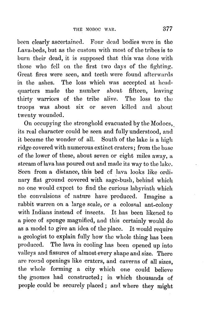
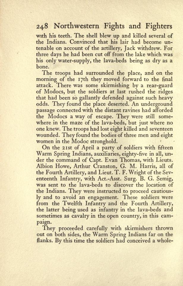
| III | April 14-17, 1873 | 1 – 16 | Captain Jack’s Stronghold in Modoc lava beds | Simpson, Meeting the Sun, 377; Brady, Northwestern Fights and Fighters, 248; Thompson, Modoc War, 77-78 | http://nahc.ca.gov/webmaster/atlas/evidence/i1052a.jpg
http://nahc.ca.gov/webmaster/atlas/evidence/i1052b.jpg
|
| II | April 26, 1873 | 0 – 1 | Sandy Butte | Murray, Modocs and Their War, 236; Quinn, Hell with the Fire Out, 152; Thompson, Modoc War, 91 | http://nahc.ca.gov/webmaster/atlas/evidence/i0647a.jpg
http://nahc.ca.gov/webmaster/atlas/evidence/i0647b.jpg
|
| II | May 10, 1873 | 1 – 2 | Soreass/Dry Lake | Murray, Modocs and Their War, 248; Quinn, Hell with the Fire Out, 159-160; Thompson, Modoc War, 98 | http://nahc.ca.gov/webmaster/atlas/evidence/i0648b.pdf |
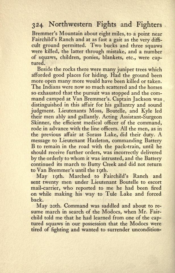
| III | May 18, 1873 | 5 (2 men and 3 women) | “near Fairchild’s Ranch” | Hasbrouck in Brady, Northwestern Fights and Fighters, 324 | http://nahc.ca.gov/webmaster/atlas/evidence/i1053a.jpg |
| II | June 7, 1873 | 4 | Near Tule Lake? | DAC, June 10, 1873, 1; Murray, Modocs and Their War, 277 | http://nahc.ca.gov/webmaster/atlas/evidence/i0649.pdf
|
TOTAL ESTIMATED NUMBER KILLED IN REGION: 2,205-2,676
*Appendix (Appx.) refers to the reference’s location in:
Benjamin Madley, An American Genocide: The United States and the California Indian Catastrophe. New Haven and London: Yale University Press, 2016.
For full bibliographical references please refer to the text or Atlas credits & references
Abbreviations used in timeline:
DAC: Daily Alta Californian newspaper (San Francisco)
DEB: Daily Evening Bulletin newspaper (San Francisco)
HT: Humboldt Times
IWP: California Adjutant General’s Office, Military Department, Adjutant General, Indian War Papers F3753
SDU Sacramento Daily Union newspaper
WOR U.S. War Department, The War of the Rebellion: A Compilation of the Official Records of the Union and Confederate Armies. 4 series, 130 volumes. Series 1, volume 50, part 1 [WOR 1:50:1], etc.
For full bibliographical references please refer to the text or Atlas credits & references